Translate

Showing posts with label Wild Atlantic Way. Show all posts

Sunday, March 17, 2019

How to Have The Cliffs of Moher All To Yourself!

Walking North from Hag's Head along the Cliffs of Moher, Ireland


Ireland's iconic Cliffs of Moher are on travel book covers, tourist brochures and most visitors to Irelands' "Bucket List"; and for a good reason-they are awe-inspiring!  If you want to have a chance to see the cliffs without the crowds, then read on...


Beautiful arches in the sea at the Cliffs of Moher, County Clare, Ireland
Looking Northward At The Cliffs Of Moher

The Cliffs of Moher are on Ireland's West Coast located in County Clare between Hag's Head (near the town of Liscannor) to the South and Doolin to the North, stretching about 12 kilometres.  These 214 meters (700-foot) tall cliffs are an impressive tourist draw that attracts scores over one million tourists a year to eager to see the sheer drop into the wild Atlantic Ocean.  Most tourists end up at the modern Cliffs of Moher Visitor Centre located around the midpoint of the cliffs.  The parking lot for the Visitor Centre is on the R-478 coastal road, and costs €8 to park your car, but then you can enter the visitor centre for free.  The center is state-of-the-art and equipped with a tourist information centre, ATM, toilets, restaurants and of course, a gift shop.


Detailed map of parking and trail head for Hags Head walk along the Cliffs of Moher, County Clare, Ireland


But... if you want these rugged Atlantic cliffs all to yourself without the crowds even in mid-August at the height of tourist season, there is another route you can take.  There is a coastal walking trail sometimes referred to as the Hag's Head Trail or the Cliffs of Moher Coastal Trail, but it is actually part of The Burren Way.  The Burren Way is a 114 km (71 miles) multi-day hike across county Clare that starts in Lahinch and ends in Corofin, crossing the Burren which is Europe's largest limestone landscapes. 
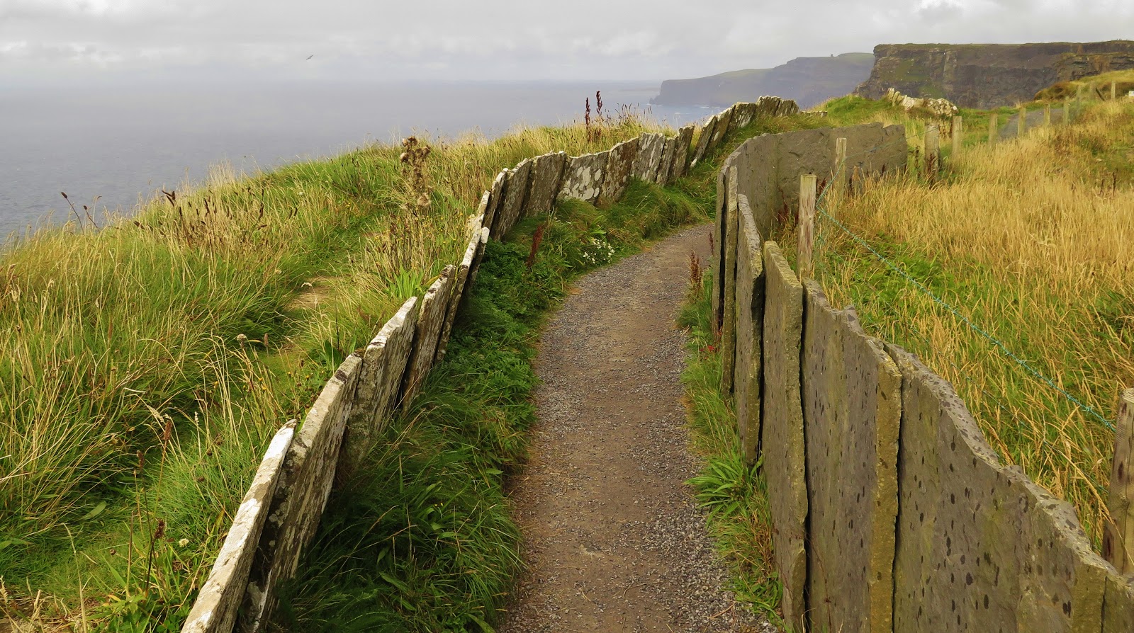


Pathway lined with slate slabs at Hag's Head, Cliffs of Moher, Ireland
Cliffs of Moher Coastal Walk


Detailed map of shuttle bus stops along the Cliffs of Moher hiking trail from Hag's Head to Doolin, County Clare, Ireland


A shuttle bus service operates March 1st through October 31st bringing hikers back and forth to their car or bus connection.  There are four access points to the Coastal Trail; Liscannor, Hags Head, The Cliffs of Moher Visitor Center and Doolin (which has five bus pick-up locations.) For shuttle-bus information and schedules see COASTAL WALK SHUTTLE BUS.  From Hag's Head to the Visitor Center it is approximately 5.6 kilometres and takes about 2 hours to walk and then from the Visitor Centre to Doolin is another 7.7 kilometres which takes about another 3-3.5 hours.  The total walk is about 5-5.5 hours depending on fitness levels and how many times you stop to take photos!  


Walk through farmers fields to the Hag's Head trailhead at the abandoned telegraph tower, Cliffs of Moher walk, Ireland
Walk Towards The Telegraph Tower


For our Cliffs of Moher experience, we parked at the Kilconnel parking lot for  €2.  The parking lot is located on private land off a farm road just past the town of Liscannor.  Heading north from Lisconnor on the R-478, turn towards the coast at the intersection of Saint Brigid's Well (worth the stop to check this Holy Site out) and then follow the signs for parking.   Once you pay the parking attendant who will direct you where to park, you walk uphill through farmers fields for about a kilometre or so to join the coastal hiking trail.   We recommend arriving early to guarantee a parking space is available. 

Please respect the private farm property and take care not to drop litter or feed the animals (no matter how cute they are!) 


Sitting on the edge of the Cliffs of Moher, County Clare, Ireland
Take EXTREME Caution Near The Edge


The hiking trail itself is quite level with only a few sets of stairs near the abandoned telegraph tower.  The path here is lined with large slabs of slate, and if you look closely at the stone, you can see fossilized worm tracks from when this rock was just mere sand on the ocean floor.  

The path does come very close to the edge of cliffs in several places.  There are no fences or safety railings on this part of the coastal cliffs trail.  The cliff's edge is often slippery, and the gusts of strong wind that can slam into the cliffs without warning are enough to bowl you over at times.  Even earlier this year in 2019, a student taking a selfie on the cliff's edge lost his footing, falling to his death.  The recommendation for children is that no child under the age of 10 walks the trail from Hag's Head to the visitor centre.  I think that as long as you are supervising your children carefully, hiking the coastal trail should not be a problem.


The Cliffs of Moher looking northward towards Doolin, Ireland


Petting some of the friendliest horses along the Cliffs of Moher coastal walk from Hag's Head to Doolin, Ireland
Making Friends Along The Hike

The weather can turn abruptly on Ireland's west coast; all the pictures in this blog post were taken within a few hours of each other.  You know what they say about the Irish climate: "If you don't like the weather; just wait five minutes!"  It's so true!  For this hike, I suggest dressing in layers with a good wind/waterproof jacket and sturdy walking shoes.  Bring along a water bottle and perhaps a snack, although the Visitor center is a good place to stop in for food.  You may also want to pack bug repellant because at certain times of year the gnats are terrible along the grassy cliffside!  Sunscreen and sunglasses are also a smart thing to bring.


The coastal walk from Hags Head to Doolin along The Cliffs of Moher, County Clare, IrelandThe walk from the Visitor Centre to Doolin is not as dramatic as the first half of the hike, yet still beautiful.  The path winds past the Centre and slopes gradually down towards the sea at Doolin.  Doolin is a great place to stop in for a pint or a dinner at a pub.  Doolin is also a great place for Irish Trad Music in the pubs.  You can also book a boat cruise to see the cliffs of Moher from a different perspective-the water.  A one hour cruise is €20 (discount for online booking), and two companies offer cruises three times per day weather permitting.  www.doolin2aranferries.com and www.obrienline.com  Doolin is also the place where you catch the ferry to the Aran Islands with the same boat companies. 


Enjoy your visit to the Cliffs of Moher even if the weather is wet; because you know how the old saying goes: 


"you can't have rainbows without the rain!"


Double rainbow on the Cliffs of Moher Walk from Hag's Head to Doolin, Ireland


Follow me on FACEBOOKINSTAGRAM  and  BLOGLOVIN'  for daily photos and updates! #slowtravel🐌 #dulgomall

Thursday, February 28, 2019

Dingle Peninsula VS Ring of Kerry

Cow in the green pastures of county Kerry, Ireland

Are you struggling to decide between driving Ireland's uber-famous Ring of Kerry and the lesser known Dingle Peninsula?  Then this is the blog post for YOU!  I have some pros and cons for each drive, to help you choose what will work better for your perfect Ireland road trip itinerary.


Sunset over the Dingle Peninsula county Kerry, Ireland
Sunset Views of the Dingle Peninsula 
I was fortunate enough to spend a week renting a thatch-roofed cottage on the actual ring of Kerry between Cahairsiveen and Killorglin, allowing me to drive around both the Ring of Kerry on the Iveragh Peninsula and the Slea Head Loop on the Dingle Peninsula.  Many folks have asked me which scenic drive I would recommend to them because they have limited time on the West Coast.  If you are getting around by public transport, then your choices are minimal, especially if you are travelling in the shoulder or off-season.   Tour buses leave from Killarney to drive around the Ring of Kerry making this a much busier road to drive than the Dingle's Slea Head Drive.  So if you want to avoid crowds, head to Dingle. If driving in Ireland makes you nervous, and you don't want to rent a car then the Ring of Kerry would be your choice, because there are very few tours offered for the Dingle Peninsula.  This article is geared towards travels who have access to a vehicle.


Views

Both the Ring of Kerry and the Slea Head drive offer stunning ocean views.  The Slea Head road is closer to the sea, whereas The Ring of Kerry has some beautiful cliff-top vistas overlooking the Atlantic Ocean.  You can also take a side road off of the Ring of Kerry and drive the 32 kilometres Skellig Ring Road to see the beautiful Cliffs of Kerry and Skellig Islands off in the distance.  
My vote for better views goes to the Dingle Peninsula because you are driving next to the ocean more than on the Ring of Kerry.

The green cliffs of Kerry near Portmagee, Ring of Kerry, county Kerry, Ireland
The Cliffs Of Kerry
Road at Slea Head , Dingle Peninsula, County Kerry Ireland
Slea Head


Historical Points of Interest

There are many archaeological points of interest on both scenic drives, yet each loop holds different and unique sites. 


Dingle Peninsula's famous early Christian church Gallarus Oratory
Gallarus Oratory, Dingle Peninsula


Slea Head has beehive huts that were used by early inhabitants and later by Christian Monks.  Gallarus Oratory is a very early Christian church that was made by hand corbeled stone in a stunning setting.  Kilmalkedar Church with its Celtic cross graveyard and ancient Ogham stone is picturesque and evocative. DUNBEG RINGFORT IS CLOSED.   If you want to see a stone ringfort, you will have to see it on the Ring of Kerry. 


Staigue stone ringfort located in the rolling hills along the Ring of Kerry
Staigue Ringfort, Ring of Kerry


Ring of Kerry has three bronze age stone ring forts; two at Cahirsiveen and a huge one at Staigue Ring Fort. The cute town of Kenmare has a  prehistoric pagan stone circle in the middle of the city, and Killarney National Park on the Ring of Kerry has a ruined castle and a few deserted abbeys to explore.

My vote is tied between these two drives; each has completely different types of historical monuments.


Attractions


Jaunting car parked on lawn of Muckross House in Killarney National Park, Ring of Kerry, County Kerry, Ireland
Jaunting Car At Muckross House


With Killarney National Park being situated on the Ring of Kerry, the town of Killarney is much better set up for tourist activities than Dingle.  Killarney Park has Muckross House and Traditional Farms which is a grand Victorian House, and it's working open-air museum farm, Ross Castle and Muckross Abbey.  You can hike many of the gorgeous trails in Killarney park, rent a bike and explore the park, rent a boat, take a boat tour or hire a jaunting car through the Gap of Dunloe. 

Mysterious Beehive shaped huts on the Island of Skellig Michael, Kerry Coast, Ireland
Mysterious Beehive Huts On Skellig Michael


Another famous tourist attraction that is along the Ring of Kerry is the Skellig Islands.  Skellig Michael is a remote island 12 miles off the Kerry coast that is one of two of Ireland's  UNESCO world heritage sites.  The islands have become very popular in the last few years because of the filming of the Star Wars movies, and you must READ THIS BEFORE GOING TO SKELLIG MICHAEL!

Honourable mention for attractions on the Ring of Kerry is Derrynane (rhymes with Mary Ann) House, which was the home of Daniel O'Connell who gained equality for Catholics in Ireland back in the 1800s.


The town of Dingle has an aquarium called Oceanworld that is very popular with children. See www.dingle-oceanworld.ie for more information.  Another favourite activity in Dingle is a boat cruise around the harbour to spot Fungie the dolphin, Dingle's wild "mascot."  Or * NEW FOR 2019* you can take a cruise from Dingle to the Skellig Islands (this is not a landing tour, just a boat trip.  Check out Dingle Bay Charters for their cruise schedule.  If you want a taste of "real Ireland" visit the Blasket Islands just off the coast of Dunquin. Dingle Bay Charters in Dingle harbour has a ferry service daily to the remote Gaelic speaking Islands.  If you don't want to make the trip all the way out to Great Blasket Island, you can stop in at the Blasket Islands Visitor Center in Dunquin.  

My vote: Offering so many more attractions and activities, I would have to say the winner for the best attractions is Ring of Kerry.

Beaches

Both the Ring of Kerry and the Dingle Peninsula have gorgeous sandy beaches, some are popular swimming areas full of frolicking children, and some are a bit more isolated and remote feeling.  For two of the most popular swimming beaches here my picks:


View of Ballinskellig Castle on Ballinskellig Beach, Skellig Ring Road, County Kerry, Ireland
Ballinskellig Beach photo by Patrick Cotter

Ballinskellig Beach (also known as Ladies Beach) along the Skellig Ring Road has a 1-kilometre long sandy strand, lifeguards on duty in July and August, and the ruins of a 16th-century castle to explore.  Most of the beaches along the ring of Kerry are located around the village of Sneem or around Ballinskellig on the Skellig Ring Road.  This is a popular beach with locals and holiday cottage renters in the summer, so finding parking can be a bit difficult.


Sandy beach of Inch Strand near Dingle on Dingle Peninsula, County Kerry, Ireland
Inch Strand Near Dingle

Inch Beach or Ínse (in Irish meaning Sea Meadow) is a sandy spit that juts out four miles into Dingle Bay making it the biggest beach in County Kerry.  This beach is perfect for swimming, beachcombing, horseback riding and surfing.  You can also drive up along the sand at Inch Beach!  There are several surf schools located on Inch Beach that offer lessons from May through September and surfing is great year round.

This was a tough decision!  My vote for the best beach would have to be Inch Strand, on the Dingle Peninsula.  


Towns


Busy shopping street of Kenmare, Ring of Kerry, County Kerry, Ireland
Downtown Kenmare

While Killarney is a large town on the ring of Kerry, for me it lacks charm and authenticity.  It seems like Killarney is all just strip malls and chain hotels with a lot of forgettable pubs and restaurants.  While there are many other charming towns on the Iveragh Peninsula like Killorglin, Waterville, Sneem and Kenmare which is my favourite on the Ring of Kerry.  Kenmare is an ancient market town that is very easy to walk with lots of shops, restaurants and pubs.  There is also a stone "Druid's Circle" in the city that dates back over 3,000 years!

Busy main road lined with colourful shops in Dingle, County Kerry, Ireland
Dingle's Colourful Main Street


The Dingle Peninsula's namesake town of Dingle, however, is one of the most charming places on the West Coast of Ireland.  Nestled on the water's edge, Dingle is a fishing port before a tourist town.  Colourfully painted little shops and restaurants line Dingle's streets and keep tourists happy.  Dingle's real charm comes out at night when locals and tourists alike head into the pubs for a pint and a session.  A "session" you may know is an evening of Irish Traditional Music, and in the evening out of almost every pub spills the sound of drums, fiddles and lots of laughter.  Dingle is rather well known in Ireland for its music scene, and it is worth spending an overnight, other than Dingle there are no other towns that I would say you must stop to visit.

The vote here would be for Dingle on the Dingle Peninsula for quality over quantity. Dingle is a super little town!

There you have it, folks!  If you have limited time on Ireland's West Coast, I would head over to Killarney National Park, then overnight in Dingle and drive the Slea Head Loop trail.  If you do have the luxury of time to do both drives I would highly recommend it, as each peninsula is unique with a unique vibe on each.

Have you been to County Kerry?  What was your favourite drive?

Follow me on FACEBOOKINSTAGRAM  and  BLOGLOVIN'  for daily photos and updates! #slowtravel🐌 #dulgomall

Sunday, February 10, 2019

Why Dingle Is My Favourite Irish Town

Harrington's Restaurant on the Main Street of Dingle, Ireland


The smell of turf fires lingered in the air on a chilly August evening, and the sounds of laughter and traditional Irish music spilled out of the pub doors as we walked past.  In the warm town of Dingle on the West Coast of Ireland, you feel more like a temporary local than a tourist.


Summer street scene in front of Murphy's Pub, Dingle, Ireland
Now, I might be upsetting a few Irish folks that are proud of their own home town, but for our family, Dingle was the perfect Irish town.  Brightly coloured tidy buildings lined the waterfront of this fishing village that was easily walkable.  Interesting artists' shops, restaurants, and pubs abound here in Dingle making it a joy to discover.  Many people pass through Dingle on the Slea Head Drive around the Dingle Peninsula but don't stop in and spend enough time in the town itself.  There seems to be something to do for everyone in this tiny West Coast town of just under 2,000 people.  Dingle is a Gaeltacht town, meaning that many folks speak Irish to each other and in their homes.  I loved overhearing a conversation or two in Irish; it made Dingle feel all the more exotic!  Here are 7 other reasons why Dingle is my favourite Irish town...


1. AQUARIUM & INCH STRAND


Beautiful sand beach of Inch Strand Dingle Peninsula Ireland
Inch Beach

A favourite thing to do with children in Dingle is to visit Oceanworld Aquarium right on Dingle's waterfront.  TIP: If you purchase tickets online you save a few Euros on the entrance fee.  
My teen Liam didn't want to go check out the aquarium (to my disappointment), so instead, we headed just a few kilometres out of town to Inch Strand.  Inch Beach or strand is a gorgeous sandy beach that sticks out four miles into Dingle Bay.  The clean waters and safe swimming of Inch Strand made it a kid-friendly place to stop.  Kingdom Waves is a surfing school on Inch Strand popular with teens and kids of all ages, and there is a convenient beach bistro to stop in and get a nice hot drink or lunch.


2. MURPHYS ICE CREAM


Murphy's Ice Cream Shop Dingle, Ireland
The Best Ice Cream In Ireland


Right along the main drag of Dingle, stop in for a treat at Murphy's Ice Cream, the most delicious ice cream in Ireland.  I am not exaggerating when I say this.  Our jaunting car driver in Killarney National Park told us that if there is ONE THING we must do in Dingle, it was to have ice cream at Murphy's.  Why is this ice cream so special?  Murphys not only uses fresh local ingredients like free-range eggs, local honey, and Dingle GIN, but Murphy also makes their own sea salt from the Dingle coast and their big SECRET: cream from the rare indigenous Kerry cow.  The high-fat cream from these small black cows you see grazing in the fields around the Dingle Peninsula is what makes this ice cream worth the €6 price tag.  You must try the Sea Salt and Caramel Honeycomb two-scoop combo, it was OUT OF THIS WORLD!  If you can't make it out to Dingle -no worries!  Murphys now has shops in Dublin, Galway, Kilkenny,  and Killarney.


3. BOAT TOUR


Dingle Bay Charters and Dingle Boat Tours in Dingle, Ireland

What would Dingle be without its loveable maritime friend Fungie the dolphin?  He's been frolicking with boats in Dingle Bay for over 30 years.  Two companies offer Fungie The Dolphin Tours around Dingle Harbour.   The one-hour harbour cruise costs €10 and is a massive hit with kids.   Dingle Bay Charters also provide ferry service to Great Blasket Island off the coast of Slea Head, a Blasket Islands Eco-Tour, a Deep Sea Fishing Excursions and new for the 2019 season: a Skellig Micheal Tour (this is not a landing tour, just an eco-tour around the Skellig Islands). 


4. SHOPPING


Palm tree in front of St. Mary's Church bell tower in Dingle Ireland
St Mary's Church
Small brightly lit passageways in Dingle Town Ireland
Dingle Charm

If a Harbour cruise is not your thing, then a pedestrian cruise around the village is perfect.  Dingle is easy to wander on foot and is set up on a Medieval Street Plan, with Main Street running up and over the top of town.  Wander into some of the outstanding craft shops that feature woollen knitwear and weaving, pottery, goldsmiths and Dingle Crystal.  There were also a few great music shops like Siopa Ceoil that sell Traditional Irish Folk music CD's, Irish instruments, song and music books and instructional DVD's.  Also, in the summer the shop held evening music concerts known as "sessions" several times a week.  Siopa Ceoil is THE place to find out what is going on musically in Dingle, located just off Strand Street in a lane marked "The Colony."


5. FISH & CHIPS


Fun menu's on the tables of Harrington's family restaurant in Dingle Ireland
Table At Harringtons!
Lightly smoked haddock and chips at Harrington's Family Restaurant in Dingle Ireland
Smoked Haddock & Chips!
All that exploring can work up one's appetite!  Our family has a rule: for one day on each vacation our son gets to choose what we do and where we eat, and in Dingle, it was fish and chips!  Our teen chose Harington's Family Restaurant on Strand Street right across from the Tourist Office.  This place felt like a classic teen joint, and there were tons of locals eating dinner there (not all teens by the way!)   Menus are glued onto each table, and the decor is random and eclectic.  The fish and chips were cooked to heavenly perfection, the burgers were homemade,  milkshakes used real ice cream, and the fries were crisp on the outside and nice and soft in the middle. I recommend the lightly smoked haddock and chips -OUT OF THIS WORLD!


6. TRADITIONAL IRISH MUSIC


Bar in Irish Pub Dingle IrelandDingle is known for its traditional Irish music scene (called Trad music), and the best place to see a Trad Music session is in the pubs.  The music usually starts around 9:30 and pubs close at 11:30.  If you are travelling Ireland with your children, it may be a bit more challenging to hear Trad music because children under 14 must leave the pubs by 9:00.  Children over 14 and under 18 however, may remain in the pub after 9:00 as long as they are accompanied by their parents (we had no problem bringing our 16-year old into the pubs).  If you have younger children, fear not, you can still hear the same musicians play at St. James Church just off Main Street at the top of town.  You can buy tickets at the Dingle Music Shop Siopa Ceoil.


7. CONNOR PASS


For a Grande Finale of Dingle, I recommend you take a drive up to the infamous Connor Pass.  Connor Pass or An Chonair in Irish Gaelic is a narrow twisting (mostly one lane) road that is the highest mountain pass in all of Ireland.  The Connor Pass road runs from Dingle to Kilmore Cross and then on to Tralee on the North side of the Dingle Peninsula, offering scenic views in either direction you are travelling.  To get to the Connor Pass head to the R560 which starts as "The Mall" from the round-about in Dingle centre.  The road then turns into Spa Road once it crosses John Street at the top of town; follow this road all the way to The Connor Pass summit.
At the summit of the Connor Pass, there is a large car park where you can stop and take in the views of both sides of the Dingle Peninsula.  This is a fabulous spot to watch the sun go down over Dingle Town and the Dingle Peninsula.


View of Dingle town from Connor Pass, Dingle Peninsula, Ireland


Have you visited Dingle?  What was your favourite activity?  Please share in the comments below, I would love some suggestions for the next time I visit this colourful Irish town...


Follow me on FACEBOOKINSTAGRAM  and  BLOGLOVIN'  for daily photos and updates! #slowtravel🐌 

Monday, December 24, 2018

The Dingle Peninsula-The "Other" Ring of Kerry


The Cliffs Of The Dingle Peninsula in County Kerry, Ireland

The Dingle Peninsula sits poised at the edge of the world and is the most western point of Ireland.  Part of The Wild Atlantic Way, The Slea Head Loop is ringed by sandy beaches, craggy cliffs, towering mountains, and ancient sites...


The Dingle Peninsula Map Of Slea Head Drive, Kerry, Ireland
Slea Head Loop Drive
The Dingle Peninsula is becoming more popular with tourists looking for an "authentic Ireland."  The extremely touristy Ring of Kerry on the Iveragh Peninsula to the South offers just as many stunning views as Dingle's 48 km (30 miles) Slea Head Loop, but the villages and people of the Dingle Peninsula are just as much of an attraction as the scenery or the historical sites. 
The towns of the Western part of the Dingle Peninsula are Gaeltacht or Irish Gaelic speaking towns.  The people of Dingle live on fishing and farming, and the pub scene with its traditional Irish music is some of the best in the country, making Dingle a place to explore for a day or two.  I would recommend driving around the peninsula in a clockwise direction, passing through Dingle to drive the Slea Head Loop, ending up back in Dingle for dinner and stay the night to soak up the atmosphere.


Inch Strand


Walking on Inch Beach, Dingle Peninsula, Ireland
Inch Strand
White house overlooking Inch Beach in County Kerry, Ireland
Starting in Castlemaine, the southern entrance to the Dingle Peninsula, take the R561 West towards Dingle.  Along the way stop in at Inch Strand or Inch Beach.  This gorgeous sandy beach sticks out four miles into Dingle Bay making Castlemaine Harbour a sheltered area for birdlife.  The clean waters and safe swimming of Inch Strand make it a kid-friendly place to stop.  There is a surfing school here popular with kids of all ages and a beach cafe to stop in at and get a nice hot drink. 


Minard Castle


Minard Castle overlooking Dingle Bay in County Kerry, Ireland
Minard Castle Overlooking Dingle Bay

Further West the winding road turns inland, and you are surrounded by lush green pasturelands full of dairy cows.  The road here becomes the N86 and passes by Minard Castle, the largest fortress on the Dingle peninsula. Built in the year 1551 by the Knights of Kerry, this castle was a stop for pilgrims on the journey to St. James' tomb in Santiago Spain.  The ruins are not safe to enter, but anyone interested in photography will want to stop at this site.
Dairy cow in the green pastures of the Dingle Peninsula
40 Shades Of Green


Passing through Dingle, you are now on the R559 or The Slea Head Loop Drive.  Maybe stop in at the deli of the Supervalu grocery store on Dingle's main street for some picnic supplies before heading out on the Ring of Dingle.  There are many places set up with picnic tables for bikers and motorists to stop for lunch along the drive around Slea Head.

 Dúnbeg Fort and Beehive Huts


The Dingle Peninsula has had people living on its fertile land since before 4000 BCE.  Located 12.5 km from Dingle, Dúnbeg Fort is a stone ring-fort hanging onto a sheer cliff overlooking Dingle Bay.  Built around 500 BCE, the defensive fort along with a central clochán or beehive hut has been standing guard for centuries...until now.  A series of violent winter storms in February 2014 and more recently this year in January of 2018 has sent over half of the fort to fall into the sea.  Dunbeg Fort was CLOSED in 2018.  You can still see a 15-minute video of Dúnbegs history for €3 at the Dúnbeg Visitor Center at the Stone House Restuarant.  
Entrance to the Fahan beehive huts on Slea Head drive on the Dingle Peninsula, Ireland

If you are dying to see some more Iron Age goodness, there are two groups of beehive huts (called clochán in Irish) are about 1 mile apart from each other along the Slea Head Drive.  The second group of clochán is a bit more impressive, and both cost an entry fee of €3.  These clochán were built around the same time as the huts on the island of Skellig Micheal that you can see off in the distance.

Stone beehive hut at Fahan, Dingle Peninsula, Kerry, Ireland
Beehive huts At Fahan


Slea Head, Dunquin and Clogher Head

Cliffside view of Slea Head on the Dingle Peninsula, County Kerry, Ireland
Slea Head Drive

A few kilometres past the beehive huts, the road turns the corner around the famous Slea Head.  Marked by a large white crucifix and a scenic pullout to stop to take photos of the Blasket Islands and Dunmore Head.  Dunmore Head is the westernmost point of mainland Ireland. The road gets impossibly narrow at this point and motorists were pulling in their side mirrors to squeeze past each other.


Dramatic winding road down to the water at Dunquin Pier, Dingle Peninsula, Ireland
Dunquin Pier
Less then a km down the road there is a parking lot by the little village of Dunquin, or in Gaelic Irish: Dún Chaoin.  Many ruined stone houses in this small village are picturesquely scattered along the coast.  Before the 1845 potato famine in Ireland, 40,000 people lived on the Dingle Peninsula.  After the famine, the number people living here was vastly reduced and villages became almost ghost towns.  Today the population is up to 10,000 and Dunquin is a favourite spot for summer homes.  

Take a walk down the dramatic switchback road to the Dunquin Pier where until 2014 the boats used to depart for the Blasket Islands (now the ferry leaves from Dingle Harbour).  The Great Blasket Centre is an excellent place to learn about the Blasket Islands, and also to stop for lunch at their cafeteria if you didn't bring lunch with you.  The Blasket Islands are a group of six islands off the coast of the Dingle Peninsula and was one of the few places in Ireland that were not affected by the potato famine which also helped retain their ancient Gaelic culture. 

View across the water of Clogher Head, Dingle Peninsula, County Kerry Ireland
Clogher Head 

Another good place to stretch your legs and go for a walk is Clogher Head just to the North of Dunquin.  There is a "scenic pullout" just past the turnoff to The Great Blasket Centre where the view is spectacular.  A short and windy fifteen-minute walk from the parking area leads out to Clogher Head where you can catch stunning views of The Blasket Islands, The Three Sisters and Mount Brandon to the North.  If you are into more serious walking, consider the Dingle Way a 179 km walk around the Dingle Peninsula that starts and finishes in the city of Tralee.  Click the link for more information on the Dingle Way walk.


Gallarus Oratory

Ancient stone Gallarus Oratory on the Dingle Peninsula, County Kerry, Ireland
The entrance of Gallarus Oratory
The Slea Head Drive turns inland now.  Turn off the R-559 following the signs towards Gallarus/Galros.  At the site, there is a big parking lot with a small visitors center that has a coffee shop, public washrooms and a small movie theatre that gives you information on the Dingle Peninsula and the historic sites that abound here, including Gallarus Oratory.  
Gallarus (rhymes with walrus) is about 1,300 years old as far as the archeologists can tell.  An Oratory is a small room for prayer, usually in another building like a hospital or airport.  In this case, Gallarus Oratory was used as an early Christian church and is one of the best preserved in all of Ireland.  This tiny church was built using the dry-stone corbeling method, just like the beehive huts on Skellig Micheal which date back to around the same time.  There is still some debate around the age of Gallarus Oratory and the use of the little stone building.   If you step inside the structure and let your eyes adjust to the dim light, you can almost feel the presence of the monks gathered together intimately to worship Christian style.


Kilmalkedar Church

Ogham stone and Celtic cross graveyard in front of Kilmalkedar Church ruins
Ogham Stone In Front Of Kilmalkedar Church
Also located on the R-559, is Kilmalkedar church a favourite place for lovers.  What?  A ruined old Irish church is a romantic spot!?! The church of Cill Mhaoilcheadair was a built in the Medieval Romanesque style 12th century as a Norman center of worship, but it was erected on a pre-Christian holy spot.  The reason we know this is because of the large Ogham stone in front of the church that dates back to 600 BCE.  This Ogham stone has a hole in the top of it where people would come to be handfasted (pagan marriage) by touching thumbs through the hole with their surrounding ancestors as witnesses.  This ceremony is a vow of marriage for a year and a day, so be careful if you decide to try the ritual!  There is also a sundial stone, an alphabet stone, and some early Celtic Christian crosses.


Dingle Town


The colourful buildings line the streets of Dingle in County Kerry, IrelandThe town of Dingle or Daingean Ui Chuis in Gaelic is the highlight of the Dingle Peninsula.  Brightly coloured houses, shops, and restaurants line the streets that lead to the waterfront.  The town public parking lot on the waterfront is filled with tour buses during the day, but at night, even though there are still many tourists, the town feels quieter and more relaxed.  There are lots of great restaurants for any budget, many pubs and loads of ice cream shops in Dingle.   The large tourist information center next to the car park on the waterfront is a wealth of information.
Remember Murphys Law when in Dingle:  Murphys Handmade Ice Cream for the most fantastic ice cream and Murphys Pub for a taste of traditional Irish food and music every evening.   Dingle was one of our favourite towns in Ireland and our teenager Liam loved it so much; we ended up going back for a second visit!  On our next trip to Ireland, we are putting a two night stay in Dingle on our itinerary for certain.


Connor Pass


Warning sign for Connor Pass, Dingle Peninsula, IrelandFor a thrilling drive out of Dingle heading North towards Tralee, you can take the jaw-dropping, nail-biting R-569 Connor Pass or An Chonair in Irish Gaelic.  The Connor Pass is a narrow twisting (mostly one lane) road that is the highest mountain pass in all of Ireland.  The Connor Pass road runs from Dingle to Kilmore Cross on the North side of the Dingle Peninsula, offering scenic views in either direction you are travelling.  


Pullout near the waterfall on the Connor Pass Road, Dingle Peninsula, Ireland
Waterfall Pullout 


If you are heading to Dingle from Tralee in the North, the road is the R-560 that turns into the R-569.  On the North slope approaching the summit of Connor Pass, there is a pullout next to a small waterfall.  This little car park is the trailhead to a path that leads uphill for about 5 minutes to a crystal-clear glacier created lake called a corrie lake.  This scenic lake is a great spot to stop for a picnic!


Summit of Connor Pass looking North to Brandon Bay, Dingle Peninsula, County Kerry, Ireland
Connor Pass Summit Overlooking Corrie Lakes


At the summit of the Connor Pass, there is a large car park where you can stop and take in the views of both sides of the Dingle Peninsula.  Looking towards the North (pictured to the right) Corrie Lakes far below you, Brandon Bay and as far off as the Aran Islands in County Galway.  Looking to the South of the summit, you are about 1,500 feet up above the town of Dingle (pictured below).


Looking South from Connor Pass Summit Overlooking Dingle, Ireland
Connor Pass Summit Overlooking Dingle


The Dingle Peninsula offers so much for every type of traveller.  Astonishingly beautiful coastlines, isolated walks, ancient archeology and culturally rich towns where traditional Irish language, crafts, and music are not only surviving but thriving! 


Follow me on FACEBOOKINSTAGRAM  and  BLOGLOVIN'  for daily photos and updates! #slowtravel🐌 #dulgomall