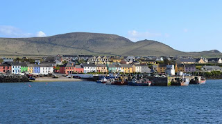
Everyone knows the Ring of Kerry, many may be familiar with the Ring of Dingle, but few know of the Ring of Skellig on the tip of County Kerry's West Coast. This drive an extension of the Ring of Kerry and the jumping off point for the mystical Skellig Micheal Island...
 |
| Gortaforia |
 |
| Skellig Ring Map |

The Skellig Ring Road is a 32 km/20-mile loop off of the Ring of Kerry that is just as beautiful as the Ring of Kerry, but WAY less touristed. That's right, no tour buses folks! The Skellig Ring Road is the R565 (which looks like a one-lane alley at times) and is far too narrow to allow tour buses. The turnoff for the Skellig Ring was just past the town of Cahersiveen on the N70 which is the Ring of Kerry. Look for the signs heading to Portmagee (An Caladh in Irish), or if you are coming from the opposite direction on the Ring of Kerry, you will turn left onto the R567 towards Ballingskelligs, just past Waterville.
 |
| Beautiful Portmagee |
 |
| The Moody Skellig Islands looming offshore |
 |
| Chocolate Heaven |
Just 10 minutes down the road further from Portmagee to Ballinskelligs is beautiful St. Finians Bay which is a beautiful beach and The Glen where Skelligs Chocolates is located. The chocolate factory is a family run business and is an "open-air concept" factory meaning you can actually watch the chocolates being made! There is a cafe in the building called the Puffin Cafe that is open from Easter to the middle of September that serves hot beverages and baked goods. The hot chocolate is fantastic! There is also a beautiful beach in The Glen.
 |
| Ballingskellig Castle Photo by Stefan Schebelt |
For history enthusiasts, there are plenty of Heritage sights and Sacred Places along the Skellig Ring Road including a ruined castle, a ruined abbey, a holy well, and standing stones called "moon-stones" because they are aligned with the path of the moon...just to name a few! Ballingskelligs Beach is a gorgeous long beach of golden sand and a picturesque castle! Lifeguards are on duty in the summer, and this beach is a very popular swimming beach with the locals in the summer.
 |
| Cliffs Of Kerry Photographed From Bray Head |
Ballinskelligs or "Baile na Sceilge" in Irish, means "town of the rocks" and the rocks referred to here are the famous Skellig islands about 12 miles off the coast. Ballingskelligs is a Gaeltacht which is an Irish language speaking village. Ballingskelligs had a monastery dedicated to St. Michael here called "Cill Rialiag" that was related to the monastery on Skellig Michael, and many of the monks who abandoned life on Skellig Michael settled here in the 12th century. Today the historical remains of Ballingskelligs leave you with a castle on one end of town and an evocative ruined abbey with a fabulous graveyard on the other!
For more information on historical sites, hit this link on Ballinskelligs Tourism site.
 |
| Views Down On The Skellig Ring |
There is a tourist information centre on the main drag in Ballingskelligs across from the beach. You can find information here about how to get to St. Michael's Well and the moon-stone alignment that you can hike to from the Cil Rialiag artists village.
The Skellig Ring Road splits into two roads just past Ballingskelligs the R566 (which is what the R565 turns into) and off to the right the R567. Both roads then hook up with the Ring of Kerry (N70).

The Skellig Ring was just a small detour off the beaten path from the world famous Ring of Kerry that most people fly past in their cars, yet felt like it was miles away from any kind of tourist hotspot. Back home at our little thatch-roofed cottage, we settled down by the stone fireplace next to our cozy turf fire (which smelled out of this world!) A pint of Guinness and some handmade chocolates from the factory at the edge of Ireland completed our local slow-travel experience.
Have you ever had an off-the-beaten-path experience next to a major tourist draw? I would love to hear about it in the comments below❣
Follow me on FACEBOOK, INSTAGRAM and BLOGLOVIN' for daily photos and updates! #slowtravel🐌 #dulgomall
Follow me on FACEBOOK, INSTAGRAM and BLOGLOVIN' for daily photos and updates! #slowtravel🐌 #dulgomall


No comments:
Post a Comment