Translate

Wednesday, October 31, 2018

Skellig Michael-Ireland's Wild West

Approaching Skellig Michael from the water, West Coast of Ireland


There is no other place in the world like Skellig Michael.  Isolated.  Dramatic.  Haunting.  A trip to Skellig Micheal is a trip back through time to another world so vastly different that it seems unlikely that it could be real.
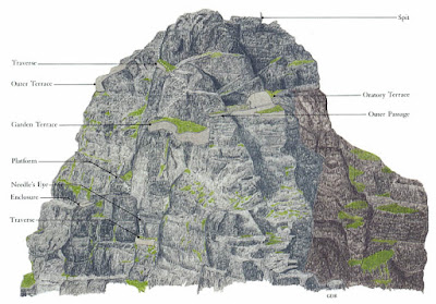

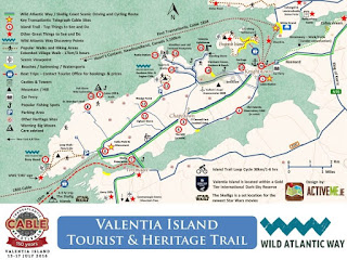
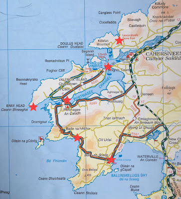
Map of Skellig Michael, Portmagee, South West Coast of IrelandThe Skellig Islands (Na Scealaga in Irish) are two islands off the South West Coast of Ireland's County Kerry and the Skellig Ring Road.  The islands lie 13 km off the coast, like two remote pyramids floating in the Atlantic Ocean.  Skellig Michael, (sometimes referred to as Great Skellig) is the larger of the two Islands and was home to one of Irelands first Celtic Christian monastic settlements. At the same time, Little Skellig is home to an important bird sanctuary.  This is why Skellig Michael is one of the two UNESCO World Heritage Sites of Ireland.

Getting to Skellig Michael is half of the adventure.  Boats leave for Skellig Micheal daily from Portmagee.  Because the Skelligs are very fragile, they are protected by UNESCO and are limited to the number of daily visitors allowed on the island.  You must have a reservation to go to the Skellig Islands, and they fill up months in advance.   Read this TRAVEL GUIDE TO SKELLIG MICHAEL to learn all about getting tickets to the Skelligs.


Even with a reservation, the weather will be the ultimate determiner if you get to see the Skelligs or not.
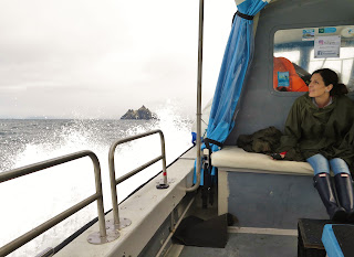

Aboard the boat Mary Frances heading to Skellig Michael from Portmagee, County Kerry, Ireland
Aboard The Mary Frances
The tour to Skellig Michael leaves Portmagee in the early morning around 9am.  Our trip was delayed a bit because of choppy seas and foggy weather.  The captains running the boats were waiting to hear from the rangers living on Skellig Michael on whether it was safe to land or not.   The ride out to the islands takes anywhere from 40 minutes to 1 1/2 hours, depending on the size of the boat and ocean conditions.  If you are prone to seasickness, TAKE your medicine, those waves can get big! 

We donned our rain ponchos the crew members gave us and headed off into the fog on our small boat, the Mary Frances operated by Captain Nealie Lyne.  The journey was to take about an hour, and the waves were quite tame.  I thought: "no problem" as we sped out into Portmagee Channel, but as soon as we headed out into open water, though, I realized I was having trouble keeping down my Irish oatmeal from breakfast.  I just kept staring at the horizon...
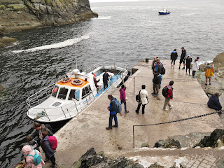

Landing at Blind Man's Cove, Skellig Michael, County Kerry, Ireland
 Landing At Blind Man's Cove


Our excitement quickened when we heard seabirds, and a large triangle appeared in the mist, first one and then the second.  My first thought was that these are just the tops of giant mountain peaks poking out of the ocean, and then we saw it-Great Skellig or Sceilig Móhr!  We had to wait our turn to land the boat at the one cement pad at the entrance to a sea cave on Skellig Micheal called Blind Mans's Cove.  It was really tricky getting off the moving boat, and I could see why many people have a hard time getting off the ship.


Once our group got off the Mary Frances, we walked along a path leading to the lighthouse and the trailhead going up to the monastery.  Much of the trail here is covered with a roof because of the danger of falling rock (and it's a sweet relief from worrying about birds pooping on you).  At the end of the pathway, a ranger meets you to let you know about the dangers of climbing the 180 meters (600 ft) to the top of Skellig Michael.  There have been three deaths on the climb to the top and five serious injuries since 2009, so take extreme care when climbing the 618 steps to the monastery.
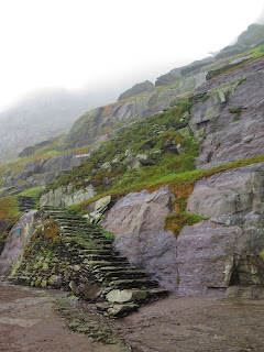
The beginning of the stairway to the top of Skellig Michael, County Kerry, Ireland
Beginning Of The 618 Steps
Footpath to the Ranger's house on Skellig Michael, County Kerry, Ireland
Rangers House On Skellig Michael


The steep climb up the stairs on Skellig Michael, County Kerry, Ireland
Climbing Up Skellig Steps

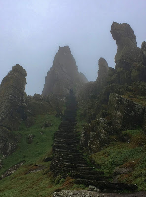
The climb up the steps of Skellig Michael was as much a physical journey as a mental and spiritual one.  The higher you climb on the hand-carved uneven steps to the monastery, the more you felt like you were ascending backwards through time.  
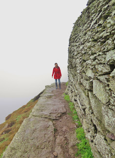
The stairs are steep, and even after a short climb, you are high above the sea and open to the wind gusts that whip around the rocks.  There is not much in the way of handrails, and you can't help but think that one false step could send you down into the crashing waves. 
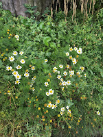
Wild Herbs growing on Skellig Michael planted by the Monks hundreds of years ago, Skellig Michael, County Kerry, Ireland

Contrasting the sharp rock cliffs, were the pretty flowers and wild herbs growing all over the island; reminders that the monks were healers and produced their own medicinal plants as well as vegetables.  There was no dirt on the Skelligs, so the monks had to make soil by hauling seaweed up the 600 steps.


The Wailing Woman Rock on Skellig Michael, County Kerry, Ireland
The Wailing Woman

There are many interesting geological features on Skellig Michael, all with exciting names such as "The Needle's Eye," "Rock of the Women's Piercing Caoine," "The Stone of Pain," and "The Wailing Woman."

You may recognize "The Wailing Woman" Rock from the latest Star Wars movie "The Last Jedi," where the young heroine Rey slices the rock in half with her lightsaber.  Oops, my bad!!!  Thankfully most of the Star Wars fans stop here for photos, and you can pass a bunch of people on the way up to the monastery.

Panorama of Christ's Saddle on Skellig Michael, County Kerry, Ireland
Christ's Saddle

The staircase called "The Way Of Christ" on Skellig Michael, County Kerry, Ireland
Climbing "The Way Of Christ"


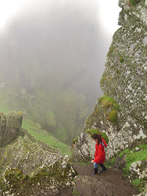
As we climbed ever higher, the fog thickened even more.  It was the beginning of August and the end of the Puffin season.  The Skellig Michael guide told us we may see a few Puffin stragglers still hanging around the top of the island, but we would never have been able to have seen them through the dense fog.  We came to a lush green meadow called "Christ's Saddle," which was an excellent place to rest and catch your breath before the hike to the monastery.  Here there is another ancient and more treachours path that leads down to the ocean carved by the monks, but it is fenced off to visitors. 

Christ's Saddle is the only flat, fertile land in the centre of the island and is about 3 acres in size.  The monks of Skellig Micheal used this place to farm, and archeologists have dug up this area and found traces of medieval crop farming.  

The steepest part of the climb up to the top of the Skellig is from Christ's Saddle, and it is aptly called "The Way Of Christ."  Here there is nothing to hold onto as you ascend the final steep steps up to the hermitage at the top of the rock.


Gates to the monastery of Skellig Michael, County Kerry Ireland
Monastery Gates
Monastery Terrace on Skellig Michael, County Kerry, IrelandFinally, you reach a flat spot along a high wall that holds up the inner sanctum of the monastery's garden.  The feeling of excitement is almost palatable at this point, and you walk through the centuries-old gate crossing the threshold into the sacred space.
A Skellig Michael guide awaits you in amongst the structures at the top and explains to your group how the monks lived here at this remote location for hundreds of years.  The monastery was said to have been founded by Saint Fionán sometime in the fifth century.  Saint Fionán (or Finian in English) was said to have been born in 470 CE and died of the plague in 549 in the Boyne Valley.  
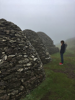

Beehive hut houses of Skellig Michael, County Kerry Ireland
Beehive Huts


Exploring inside the Monk's cells on Skellig Michael, County Kerry, Ireland
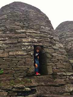
Exploring The Monk's Cells
Saint Fionán founded many Augustinian monasteries in Ireland and was one of the fathers of Irish Monasticism.  Augustinian monks were hermits and lived in remote fraternal communities following the teaching of Saint Augustine, who believed in truth, love, learning and beauty.  The monks removed themselves from regular life to be immersed in nature, and in St. Augustine's words, "God's beauty so ancient and so new."  This allowed the monks to become engaged in learning and copying out Christian scriptures and the Bible by hand and in Latin, embellishing their work with Celtic drawings very similar to the Book of Kells.


Oratory of Skellig Michael where the monks prayed several times a day, Skellig Michael, County Kerry, Ireland
Oratory On The Terrace


At the monastery, there are six intact clochán or beehive huts and remains of several more.  These structures are where the monks lived on the island and are built by a dry stone technique called corbelling, where no mortar is used to produce the shelter.  Considering that these huts are probably close to a thousand years old and they were completely dry and cozy inside, I would say these monks knew what they were doing! 
There are also two oratories here on Skellig Michael. Their shape is built like a square to fit in more monks for worship, which occurred several times a day.  
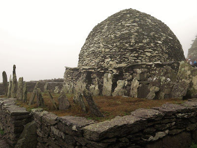

Monk's gravemarkers on Skellig Michael, County Kerry, Ireland
Graves On Skellig Michael

There is an evocative little cemetery on Skellig Michael with hand-carved stone crosses to mark the unnamed graves of the monks who died here.  How many died from disease, Viking raids, or just slipping off the rocks?  Experts believe that no more than 12 monks at a time lived here with one Abbot.  I don't believe that. I bet there were more monks stuffed in those clocháns then we think; how else would you stay warm on those freezing winter nights?  
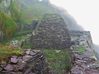
The monastery was more advanced than we think it could have been.  There were cisterns to catch rainwater, terraces with vegetable gardens or perhaps where some livestock was kept.   Besides the two oratories on the grounds, there is a Medieval chapel that has a window looking out over to the mainland.  There is a grave at the chapel of two small children here dating from the 1800s; the lighthouse keeper's children. 
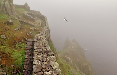

Garden terrace of the monastery of Skellig Michael, County Kerry, Ireland
View From The Terrace On Skellig Michael
I was chatting up the guide who gave us the tour, and he lives on Skellig Michael for the May to October tourist season.  He plants a veggie garden each year, but this year the rabbits got into his garden plot and ate the whole thing.  Wait; what? Rabbits on Skellig Michael?  Apparently, the lighthouse keepers kept rabbits as livestock, and they may have been imitating what the monks had been doing centuries before.  The guide had also told me there was a small and treacherous path leading up to the peak of Skellig Michael above the monastery.  Located here are the remains of two huts or oratories and cisterns for rainwater.  This place was either for even stricter hermits to live in or as a hideout from Viking raids.
The treacherous climb back down the steps on Skellig Michael, County Kerry, Ireland
Climbing Back Down Skellig Michael


Raids by Vikings became a regular occurrence at Skellig Michael by the 9th & 10th centuries. The monks were either murdered or taken as slaves by the Norsemen.  Also, around this time, the Christian church was changing and wanted more control over remote outposts such as Skellig Michael.  The monastery was abandoned by the 12th century and moved to Ballinskelligs, where an abbey was built.   

The average time for tourists on Skellig Michael is three hours; 45 minutes to walk up the 618 steps, 45 minutes to explore the monastery and 30 minutes to walk back down to the boat dock. Walking down the staircase proved more challenging than climbing up them.  Wobbly legs on slippery steps along the edges of cliffs is a sure way to get your adrenaline pumping!  


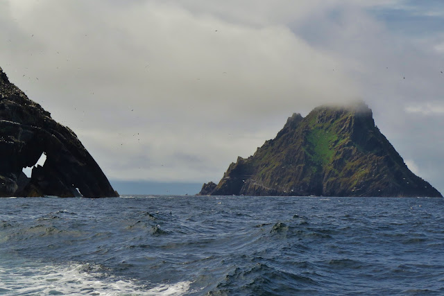
Gannet colony on Little Skellig Island, County Kerry, Ireland
Gannets On Little Skellig


But the adventure isn't over after you get back on your boat!  The captain takes you around Little Skellig Island, which is home to the most significant colonies of Northern Gannets in Ireland; 23,000 nesting pairs live here.   These beautiful birds are graceful, loud and cover the island of Little Skellig in guano, so it appears white every summer and then returns back to black rock as the winter rains and ocean waves wash it clean again.  


Once safely back at Portmagee, the contrast of our modern world compared to the Christian monk's simple existence on Skellig Micheal seemed almost incomprehensible.  The achingly raw beauty of this island contrasts the harsh environment the monks needed to endure to survive in.  It makes you realize that as the Dark Ages gripped the rest of Europe, the flame of knowledge and devotion burned bright on this tiny rock on the edge of the known world tended by a few fearless men who believed in God's beauty so ancient and so new.  


Follow me on FACEBOOKINSTAGRAM  and  BLOGLOVIN'  for daily photos and updates! #slowtravel🐌 #dulgomall
Friday, October 19, 2018

Valentia Island Ring Drive: The Edge Of Ireland


Valentia Island Ring Drive: The Edge Of Ireland

Valentia Island sounds so exotic; conjuring up images of sunny Spain in your mind not the rugged western point of the Iveragh Penninsula, Ireland.  This corner of  Ireland offers up dramatic scenery served with a slice of rural old world charm.

Valentia Island is a tiny island 7 miles long and 2 miles wide, with less than a thousand people living there.  This close-knit community just off the Ring of Kerry is primarily a Gaeltacht, meaning that Irish is the predominant language here and the economy is mostly fishing and farming.  There is a fair amount of tourism on Valentia Island because it is close to the UNESCO world heritage site Skellig Michael, and is also an extension of the scenic The Skellig Ring Road Drive.  You can make Valentia Island part of your Skellig Ring Drive as we did, or explore it as a separate day trip from the Ring of Kerry.

Valentia Island Ring Drive: The Edge Of Ireland
After visiting the two nearby Ringforts of Cahersiveen and the ruins of Ballycarbery castle "over the water" from Cahersiveen (which is what the locals call the area across the river from Cahersiveen), we decided to head to Valencia Island to check out the spectacular panoramic views.

There are two ways to get to Valencia Island the long Maurice O'Neill Memorial bridge that connects Valentia Island to the mainland at Portmagee or the short car ferry that takes you from Reenard Point just West of Cahersiveen to Knightstown on Valencia Island.  
Valentia Island Ring Drive: The Edge Of Ireland
Boats At Reenard Point


Valentia Island was perhaps named after its trading connection with Spain during the Middle Ages.  The Irish name for this island is Dairbhre meaning "Oak Wood" as this was once home to a sacred grove of oak trees where the powerful blind Druid Mug Ruith once lived.  He was one scary dude, and there are plenty of myths about him!
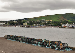
A fun way to get to Valentia Island is the small car ferry that takes the 1km trip back & forth (8:00-21:00) from Reenard Point to Knightstown.  The car ferry costs €7 and operates from April to October, mainly hauling day-trippers back and forth to cute little Knightstown which is Valentia Islands main settlement located right on the waterfront.  Stop in for a coffee at the charming little Knights Town Cafe on Market Street just up from the ferry dock. As of 2018, the cafe is under new management, and the cafe has completely turned around from its previous poor service/and overpriced food.

Valentia Island Ring Drive: The Edge Of Ireland
Crab Traps At The Ferry Dock


There are some really cool things to see on Valentia Island.  One thing is the tetrapod trackways on the North side of the Island.  There is a free parking lot at the trailhead that leads you down a short but steep path to the rocks.  These prehistoric footprints were made by crocodile type critters that were the first creatures to come out of the oceans onto solid ground. The tracks were frozen in stone 365 MILLION years ago, and are some of the oldest signs of life on land!  


Valentia Island Ring Drive: The Edge Of Ireland
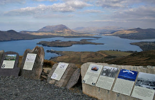
Geokaun Mountain View Point

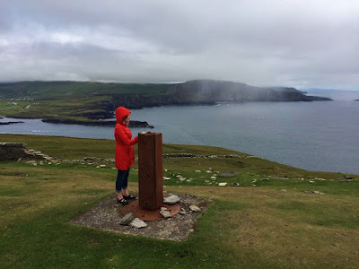
Another place to visit is Geokaun Mountain, Valentia Island's highest point.  You can hike up or drive to the summit for 360-degree views of the surrounding Iveragh Peninsula, Dingle Peninsula and Skellig Islands.  It costs €2 for pedestrians or €5 per car entry fee, and there is a 1km peak walk with over 50 interpretive plaques that tell you about the history, myth, geography, flora & fauna of the area.  There is also a viewing platform on the top of the 600ft Fogher Cliffs where you can get very close to the edge-don't worry there is a guardrail here.  For more information go to www.geokaun.com.


Valentia Island Ring Drive: The Edge Of Ireland
Bray Head Trail 

Our main activity on Valentia Island that day was the hike to Bray Head that our Airbnb host recommended to us.  The Bray Head Loop trail is an easy 5km (60-90 minute) walk that slopes upward from the parking lot to the Bray Head tower, then walks along the 700-foot cliffs before the trail turns inland once again, passing through pasturelands until you return to the car park.  Many people just walk the 2km to the tower and double back to the parking lot.  The car park costs €2, and there are picnic tables and a butt-hut here, which makes it a great rest stop.   Because the weather systems are blowing in directly off the Atlantic Ocean, the conditions are continually changing.  Wear a windbreaker or waterproof coat even in the middle of summer because it gets very windy on the cliffs. Also perhaps some sensible walking shoes since you are trudging through a pasture in the second half of the trail back to the car park.


Valentia Island Ring Drive: The Edge Of Ireland
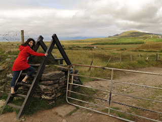
Stile Over Stone Wall At Bray Head

"We have travelled many miles, over hedges and stiles"... goes the traditional Christmas carol. Stiles are ladders that climb over fences, and there are A LOT of dry stone fences in Ireland.  These fences use no mortar to hold the stone together, just gravity.  Dry stone fences are a common sight in Western Ireland, and if you want to learn more about this ancient farming tradition and where to see the best stone walls in Ireland see dochara.com there's lots of information on all things Irish there!

Valentia Island Ring Drive: The Edge Of Ireland
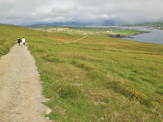
The path to Bray Head Cliffs


The "hike" to Bray Head is more of gentle  2km walk up the slope to the cliff head.  Once up top, there are sharp drops off the cliffs with NO GUARDRAILS!  Keep a close eye on children.


Valentia Island Ring Drive: Bray Head Hike
Remains Of Drystone Beehive Huts


Watch for the remains of some ancient beehive huts to your right as you wander up to the Bray Tower and the cliffs.  These huts were built with the dry stone technique common in the Bronze age on the Skellig Coast and were probably associated with the monastery on Skellig Micheal (the islands on the horizon in the picture).  There are also 12 "decorated stones" in the field here with early Christian crosses and Pagan geometric symbols, confirming this was a monastery site.

Valentia Island Ring Drive: Bray Head Hike
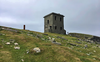
Bray Tower


At the top of Bray Head is the remains of an abandoned two storey tower built in 1815 by the English army during the Napoleonic Wars. This tower was part of a system of towers along the west coast of Ireland and was in use until the end of WWII.   I had fantasies of buying it and opening a fantastic B&B here...who can say "hot tub off the veranda?"


Valentia Island Ring Drive: The Edge Of Ireland

Valentia Island Ring Drive: The Edge Of Ireland
Cliffs of Kerry From Bray Head


The views of the Skellig Coast just kept changing as we watched the weather systems come in off the Atlantic!

Valentia Island Ring Drive: The Edge Of Ireland

The cliffs are an abrupt drop, but if you sidle up to the edge and look down, you may see some wild goats or "pucks" roaming around on the rock ledges.  In the photos, they look like little white dots, but they are definitely wild mountain goats!


Valentia Island Ring Drive: The Edge Of Ireland
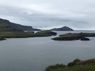
View Of The Skellig Coast

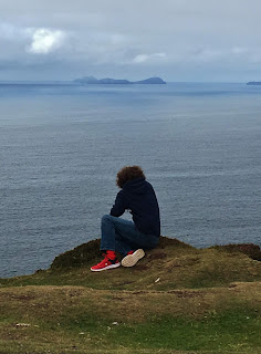
It was interesting to watch the weather systems come in off the Atlantic; sun, wind, rain, repeat!  We also watched the Skellig Island tour boats coming back to Portmagee from their trip to the famous Skellig Micheal.  It was sobering to think the next stop past the Skellig Islands is North America!


Valentia Island Ring Drive: The Edge Of Ireland
 Returning From Skellig Micheal


To complete the Valentia Island Ring, head over to the R565  (which is the Skellig Ring Roadfrom the Bray Head car park.
This takes you past Foilhommerum Bay where the first ever transatlantic telegraph cable was laid in 1865 connecting Europe to Newfoundland, Canada.  Continue along the road until you get to the bridge that crosses Portmagee Channel.  Next to the bridge is the Skellig Experience Visitor Centre where you can learn about the history, archaeology and wildlife of Skellig Islands.


Valentia Island Ring Drive: The Edge Of Ireland
Bridge To Portmagee

The Skellig Visitor Centre is a great place to visit before your boat tour to the Skellig Islands, or as a consolation activity if your boat landing tour to Skellig Micheal is cancelled due to bad weather.  Crossing over the Maurice O'Neill Memorial Bridge, you end up at Portmagee's marina.  This is marina is where the Skellig Michael boat tours leave from. If you want to stop for a bite to eat, a pint or a lovely cup of tea in Portmagee, I recommend the Fisherman's Bar right across the street from the Marina.  It's the place the locals recommended to us, and it was the perfect end to our Valentia Island Ring drive!


Sweeping views and rugged coastal terrain are the hallmarks of Ireland's Skellig Coast.  Valentia Island has them both and so much more to offer in history, culture and nature. I hope you get out, and explore it too! 


Follow me on FACEBOOKINSTAGRAM  and  BLOGLOVIN'  for daily photos and updates! #slowtravel🐌 #dulgomall

Saturday, October 13, 2018

Ring Forts Of Cahersiveen

Ring Forts Of Cahersiveen

Ringforts or "Cahir" in Irish, are mysterious remnants of Ireland's unique Celtic past.  The stone forts are connected to the land by history, myth and legend.  Hidden away off the Ring Of Kerry,  there are ancient stone ringforts you can have all to yourself to explore!


Ring Forts Of Cahersiveen
Crossing the Bridge at Cahirciveen

I am always hungry for history.  Our 1-week stay near Cahersiveen on the Ring of Kerry was an opportunity for 🐌slow-travel🐌  and to explore the local area a little deeper.  Learning that the word Cahir means "stone fort" in Irish, I figured that the town of Cahersiveen (also spelled Cahirciveen and 3 other alternate spellings) may be named after such a ringfort; and it is.  Two in fact!  I asked our Airbnb host about these stone circles and she said there were two located very close to each other, and that they were near an old ruined castle "over the water" from Cahersiveen.  Now "over the water" is what the locals call the area to the north of the town that you must cross a little bridge to get to.  From the main street of Cahirciveen (the N70) go to Bridge Street and cross the one lane bridge at the huge white "castle" that is actually an old barracks building.  For tourist info on Cahersiveen click the link.


Ring Forts Of Cahersiveen
Ringforts Are Labeled At The Top In Red 


Once you cross the river, you continue straight on to the next crossroads which is Castlequin Road and then turn left following the signs towards the Ballycarbery castle.  The stone forts are about two miles up the road, and they are within walking distance of each other.  There is a free parking lot on Castlequin Road and a clearly marked path lined with fragrant honeysuckle leads you along cow and sheep pastures.    


Ring Forts Of Cahersiveen
Cahergal Ringfort
Cahersiveen in Irish is "Cathair Saidhbhín" meaning "little Sadhbh's stone ringfort."  Who was Sadhbh?  Anglicized her name is pronounced Sieve, and she is related to the Celtic Goddess Saba, and in legend Sadbhb once lived in these forests.  Of course, in Ireland myth and legend become one.  Sadhbh was a young woman turned into a dear by black magick by an evil Druid. She was hunted by wolves until she reached the safety of the ringfort of Irish warrior legend Fionn mac Cumhaill's (Finn MacCool). Once inside the stone ring, she turned back into a beautiful woman and became Fionns lover.  But as legends go, things turn out badly for Sadhbh and Fionn, and there is a significant plot twist. 💔  This is an epic story of love and loss that shapes the history and mythology of Ireland.  To read the legend of Sadbhb and Fionn go to The Irish Myth of Sadhbh.  


Ring Forts Of Cahersiveen gypsymonika.blogspot.com
Cahergal ringfort from Leacanabuaile

Leacanabuaile ringfort is the closest ringfort to the parking lot, Cahergal ringfort is 140 meters away, and Ballycarbery castle is located at the water's edge and within strolling distance.  Walking to the ringforts passing by all the cows napping in the grass you got a sense that this scene was the same a thousand years ago.  Leacanabuaile in Irish is "Leaca na Buaile" which means "summer cow pasture."  Built high up on a rock ridge in the early 9th century, the fort was partly reconstructed when it was excavated in 1939.  The archeologists found many Bronze age artifacts such as knives and whetstones, millstones and a variety of bone hairpins and combs.
Ring Forts Of Cahersiveen gypsymonika.blogspot.com
Entrance to Leacanabuaile

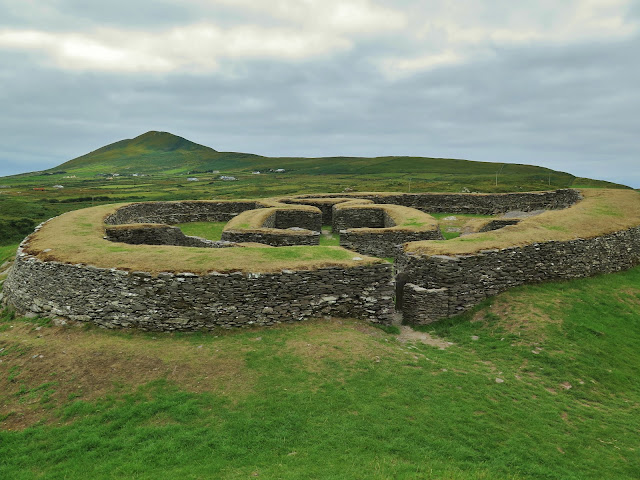
Approaching the massive 30-meter wide circle, you notice the entrance is in the East so that you are out of the blowing winds.  The walls of this structure are thick; over 2 meters of flat drystone, built with steps on the inside so you can climb up to the top of the walls to survey the land.  Inside there are remnants of 4 stone walled huts with post holes suggesting there was a wooden roof at some point.  There are also large storage chambers built INSIDE the thick walls of the ringfort that can be accessed by underground passages called "souterrain."  You can still squeeze into these passages today...if you dare!


Ring Forts Of Cahersiveen gypsymonika.blogspot.com
Leacanabuaile Ringfort With Cahergal And Ballycarbery Castle In The Background


Ring Forts Of Cahersiveen gypsymonika.blogspot.com
Surveying The Landscape


Walking through the windblown stone fort made me think of poor Sadhbh.  She may have lived in this very house!  Did she stand on top the stone walls of the fort watching the waters, waiting anxiously for her lover to return as so many past generations of Irish women did?

The Cahergal meaning "the bright stone fort" is older than Leacanabuaile fort, more restored (in the 1990s) and in my opinion not as exciting.  It is closer to Ballycarbery castle and was built in 600 C.E., and the dry stone walls are an impressive 6 meters high and 3 meters thick! The builders did not use any mortar in these walls and were not kidding around when erecting this fort!

Ring Forts Of Cahersiveen gypsymonika.blogspot.com
Ballycarberry Castle From Leacanabuaile

A few hundred meters away from Cahergal stone ring fort is Ballycarbery Castle, perched right on the water's edge.  The deserted castle tower is covered in ivy and looks quite forlorn next to the River Fertha.  There is a local legend that says there is a souterrain that leads from Cahergal ringfort to Ballycarbery Castle. 
The current structure dates back to the 15th century, but there was an older castle here built in 13th century on top of a yet older iron age ringfort.  This part of the Iveragh Penninsula belonged to the O'Shea family, and one head of the O'Shea family was Cairbre O'Shea who built the original castle and where the name Ballycarbery came from; Bally=Bhaile=town + Carbery=Cairbre.  The MacCarthy Mór was another powerful clan in the Middle Ages from Munster, and defeated the O'Shea's in the 14th century and took over Ballycarbery.  


Ring Forts Of Cahersiveen
Ballycarbery Castle Ruins


To get to Ballycarbery castle you follow the same directions as to the ring forts, but you turn left off Castlequin Road at the sign to "Caisleán Bhaile Chairbre" which is Irish for Castle of the Village of Carbery. Follow the road to the water's edge where there is a little parking lot that locals use to go clamming.  You can pull over here to get out and walk up the lane to take photos of the castle, but the land the site is on IS CLOSED TO THE PUBLIC. 


The castle was severely damaged by Oliver Cromwell's army when they blasted through Ireland in 1652.  Many of the rocks from the castle have been taken away and used to build houses and farm structures on the nearby farmlands.  The castle is the biggest on the Iveragh Penninsula and has a long history, so it's a shame that the castle is not being preserved or even restored.  Ballycarbery sits on private land, though the castle itself is owned by the government.  The castle landowner has restricted the access to the castle in 2017, so we were not able to explore the ruins.  I get it, they want to prevent further damage to the ruins and any accidents from people climbing up on the stonework; like the child that fell off the second story of the castle and badly hurt himself.  So is it worth a trip to Ballycarbery?  Let me put it this way: the castle looks good from afar but is far from good.  Taking photos on a moonlight night or from nearby Ballycarbery Beach on a misty morning and you are living the photographer's dream.


Ring Forts Of Cahersiveen gypsymonika.blogspot.com
Cute Little Guy looking For Cuddles
Oh, one thing I forgot to mention.  This sweet little lamb was shoved into our arms by its farmer when we stopped to pet it in the parking lot for the ring forts.  In return for cuddling this cutie, the farmer asks you for spare change.  One of my travel companions was actually incensed by this act, so just be aware that the price of lamb cuddles is not free in Ireland!


The green hills of  Cahirsiveen hold many legends, mysteries and ghosts.  Exploring this spot lets your imagination run wild and connects you directly with the myths of an ancient people.  Have you ever visited a place related to a myth?  Tell me in the comments section below; I would love to hear from you!


Follow me on FACEBOOKINSTAGRAM  and  BLOGLOVIN'  for daily photos and updates! #slowtravel🐌 #dulgomall