The Dingle Peninsula sits poised at the edge of the world and is the most western point of Ireland. Part of The Wild Atlantic Way, The Slea Head Loop is ringed by sandy beaches, craggy cliffs, towering mountains, and ancient sites...
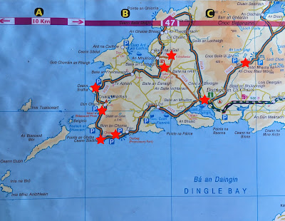 |
| Slea Head Loop Drive |
The towns of the Western part of the Dingle Peninsula are Gaeltacht or Irish Gaelic speaking towns. The people of Dingle live on fishing and farming, and the pub scene with its traditional Irish music is some of the best in the country, making Dingle a place to explore for a day or two. I would recommend driving around the peninsula in a clockwise direction, passing through Dingle to drive the Slea Head Loop, ending up back in Dingle for dinner and stay the night to soak up the atmosphere.
Inch Strand
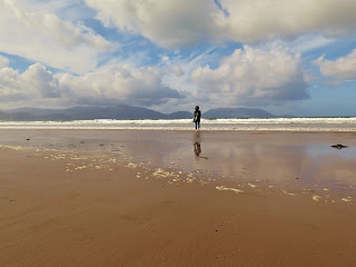 |
| Inch Strand |

Starting in Castlemaine, the southern entrance to the Dingle Peninsula, take the R561 West towards Dingle. Along the way stop in at Inch Strand or Inch Beach. This gorgeous sandy beach sticks out four miles into Dingle Bay making Castlemaine Harbour a sheltered area for birdlife. The clean waters and safe swimming of Inch Strand make it a kid-friendly place to stop. There is a surfing school here popular with kids of all ages and a beach cafe to stop in at and get a nice hot drink.
Minard Castle
 |
| Minard Castle Overlooking Dingle Bay |
Further West the winding road turns inland, and you are surrounded by lush green pasturelands full of dairy cows. The road here becomes the N86 and passes by Minard Castle, the largest fortress on the Dingle peninsula. Built in the year 1551 by the Knights of Kerry, this castle was a stop for pilgrims on the journey to St. James' tomb in Santiago Spain. The ruins are not safe to enter, but anyone interested in photography will want to stop at this site.
 |
| 40 Shades Of Green |
Passing through Dingle, you are now on the R559 or The Slea Head Loop Drive. Maybe stop in at the deli of the Supervalu grocery store on Dingle's main street for some picnic supplies before heading out on the Ring of Dingle. There are many places set up with picnic tables for bikers and motorists to stop for lunch along the drive around Slea Head.
Dúnbeg Fort and Beehive Huts
If you are dying to see some more Iron Age goodness, there are two groups of beehive huts (called clochán in Irish) are about 1 mile apart from each other along the Slea Head Drive. The second group of clochán is a bit more impressive, and both cost an entry fee of €3. These clochán were built around the same time as the huts on the island of Skellig Micheal that you can see off in the distance.
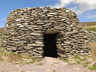 |
| Beehive huts At Fahan |
Slea Head, Dunquin and Clogher Head
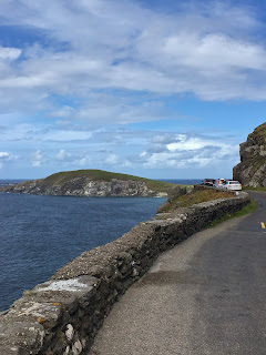 |
| Slea Head Drive |
A few kilometres past the beehive huts, the road turns the corner around the famous Slea Head. Marked by a large white crucifix and a scenic pullout to stop to take photos of the Blasket Islands and Dunmore Head. Dunmore Head is the westernmost point of mainland Ireland. The road gets impossibly narrow at this point and motorists were pulling in their side mirrors to squeeze past each other.
 |
| Dunquin Pier |
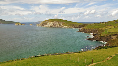
Take a walk down the dramatic switchback road to the Dunquin Pier where until 2014 the boats used to depart for the Blasket Islands (now the ferry leaves from Dingle Harbour). The Great Blasket Centre is an excellent place to learn about the Blasket Islands, and also to stop for lunch at their cafeteria if you didn't bring lunch with you. The Blasket Islands are a group of six islands off the coast of the Dingle Peninsula and was one of the few places in Ireland that were not affected by the potato famine which also helped retain their ancient Gaelic culture.
 |
| Clogher Head |
Another good place to stretch your legs and go for a walk is Clogher Head just to the North of Dunquin. There is a "scenic pullout" just past the turnoff to The Great Blasket Centre where the view is spectacular. A short and windy fifteen-minute walk from the parking area leads out to Clogher Head where you can catch stunning views of The Blasket Islands, The Three Sisters and Mount Brandon to the North. If you are into more serious walking, consider the Dingle Way a 179 km walk around the Dingle Peninsula that starts and finishes in the city of Tralee. Click the link for more information on the Dingle Way walk.
Gallarus Oratory
 |
| The entrance of Gallarus Oratory |
Gallarus (rhymes with walrus) is about 1,300 years old as far as the archeologists can tell. An Oratory is a small room for prayer, usually in another building like a hospital or airport. In this case, Gallarus Oratory was used as an early Christian church and is one of the best preserved in all of Ireland. This tiny church was built using the dry-stone corbeling method, just like the beehive huts on Skellig Micheal which date back to around the same time. There is still some debate around the age of Gallarus Oratory and the use of the little stone building. If you step inside the structure and let your eyes adjust to the dim light, you can almost feel the presence of the monks gathered together intimately to worship Christian style.
Kilmalkedar Church
 |
| Ogham Stone In Front Of Kilmalkedar Church |
Dingle Town
 The town of Dingle or Daingean Ui Chuis in Gaelic is the highlight of the Dingle Peninsula. Brightly coloured houses, shops, and restaurants line the streets that lead to the waterfront. The town public parking lot on the waterfront is filled with tour buses during the day, but at night, even though there are still many tourists, the town feels quieter and more relaxed. There are lots of great restaurants for any budget, many pubs and loads of ice cream shops in Dingle. The large tourist information center next to the car park on the waterfront is a wealth of information.
Remember Murphys Law when in Dingle: Murphys Handmade Ice Cream for the most fantastic ice cream and Murphys Pub for a taste of traditional Irish food and music every evening. Dingle was one of our favourite towns in Ireland and our teenager Liam loved it so much; we ended up going back for a second visit! On our next trip to Ireland, we are putting a two night stay in Dingle on our itinerary for certain.
Connor Pass
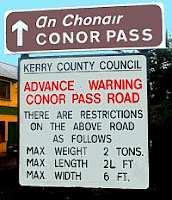 For a thrilling drive out of Dingle heading North towards Tralee, you can take the jaw-dropping, nail-biting R-569 Connor Pass or An Chonair in Irish Gaelic. The Connor Pass is a narrow twisting (mostly one lane) road that is the highest mountain pass in all of Ireland. The Connor Pass road runs from Dingle to Kilmore Cross on the North side of the Dingle Peninsula, offering scenic views in either direction you are travelling.
  |
| Waterfall Pullout |
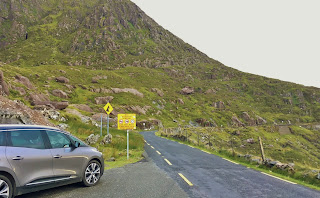
If you are heading to Dingle from Tralee in the North, the road is the R-560 that turns into the R-569. On the North slope approaching the summit of Connor Pass, there is a pullout next to a small waterfall. This little car park is the trailhead to a path that leads uphill for about 5 minutes to a crystal-clear glacier created lake called a corrie lake. This scenic lake is a great spot to stop for a picnic!
 |
| Connor Pass Summit Overlooking Corrie Lakes |
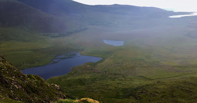
At the summit of the Connor Pass, there is a large car park where you can stop and take in the views of both sides of the Dingle Peninsula. Looking towards the North (pictured to the right) Corrie Lakes far below you, Brandon Bay and as far off as the Aran Islands in County Galway. Looking to the South of the summit, you are about 1,500 feet up above the town of Dingle (pictured below).
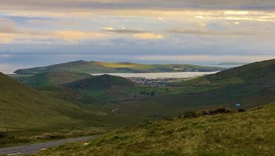 |
| Connor Pass Summit Overlooking Dingle |
The Dingle Peninsula offers so much for every type of traveller. Astonishingly beautiful coastlines, isolated walks, ancient archeology and culturally rich towns where traditional Irish language, crafts, and music are not only surviving but thriving!
Follow me on FACEBOOK, INSTAGRAM and BLOGLOVIN' for daily photos and updates! #slowtravel🐌 #dulgomall


No comments:
Post a Comment