The Ring of Kerry is famous as the quintessential slice of West Coast Ireland. It is 179 km of breathtaking views of ocean cliffs, castles, ring forts, charming villages and Killarney National Park containing picturesque lakes and the highest mountain in Ireland.
 |
| Ring of Kerry Drive |
The ring of Kerry is the N-70 Road that circumnavigates the Iveragh Peninsula and is one of the most popular tourist attractions in Ireland. Giant tour buses circle the Ring of Kerry each day leaving Killarney and travel in a counterclockwise direction, clogging up the narrow roads. If you wish to explore the Ring of Kerry you have three options: rent a car, take an organized coach tour, or take the Bus Éireann public bus. Killarney is the biggest town on the Ring of Kerry and has the bus and train station. The bus station and the Tourist Info centre is where all the big tour coach operators leave from and if you wish to take the Bus Éireann public bus you are a bit limited. The public bus departs daily at 12:45 (July-Sept) and returns you to Killarney at 5:45. While the cost is only €23, the bus only stops to drop off/pick up passengers except for an hour stop in the cute little seaside town of Sneem. You would be better off taking a minivan tour from Kenmare for €30 with Finnegan's Tours. Check the schedule: www.kenmarecoachandcab.com If you decide to drive the Ring of Kerry yourself, factor in about 4.5 hours without any stops. A good Ordnance Survey Road Atlas is an essential tool and sold in most tourist info centres for about €13.
 |
| Kerry Cows |
When driving the Ring of Kerry, most people advise you to set out in the same direction as the tour buses; counter-clockwise. Since we were staying at an Airbnb on the Ring of Kerry (aka N-70) near the tiny village of Kells, we started off in the morning driving in a counter-clockwise direction and luckily missed most of the tour buses; venturing off the beaten path by cutting over to Valentia Island or veering off the N-70 to drive the Skellig Ring Loop (R-565). Also, taking a small detour such as Staigue Ring Fort can bypass much of the mega-bus traffic. Since most people will be leaving from Killarney, we will start there and travel towards Killorglin.
Killorglin
 |
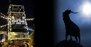
| Killorglin's Puck Fair |
Skellig Ring Road
 |
| View of Skellig Michael |
Leaving Killorglin towards Cahersiveen, you travel along the water overlooking the Dingle Peninsula and Dingle Bay. At Cahersiveen there are two iron age Ring Forts; Cahergal and Leacanabuaile. These two Ring Forts of Cahersiveen are easier to get to then Staigue Fort which is further along on the Ring of Kerry. Just past Cahersiveen is Valencia Island and a few kilometres down the road is the turnoff to The Skellig Ring Road (R-565) towards Portmagee and the jumping-off point for Skellig Michael. If you are planning to see Skellig Michael while driving the Ring of Kerry, I would recommend spending two days driving around the Ring and spend a night on the Skellig Coast. Try Airbnb.com or bnbireland.com for bed and breakfast booking information.
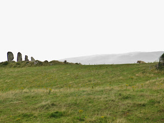
Eightercua Stone Row
 |
| Stone Row With Bull Keeping Watch |
 |
| Close Up Of Eightercua |
We decided instead to take a small side trip to Staigue Ring Fort. The turnoff to Staigue Fort is at Castle Cove where you will find a delightful pub and cafe along the way. Grab a "cuppa" (tea) here before you explore the stone ring fort set upon a windy hill. The 4km road leading to Staigue Ring Fort is so small that it often resembles a small alleyway. Go slow and prepare to reverse at least a dozen times to a small pullout to let oncoming cars pass. From the parking lot, there is a short path flanked with wild fuchsias leading over a bridge to a livestock gate and an honour system pay box asking for €1 to enter the stone ring fort.
Staigue Ring Fort
 |
| The Path To Staigue Ring Fort |

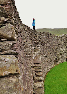
 The coolest thing about Staigue Fort is the walls. They are massive; 18 feet high and 13 feet thick with ten X shape flights of stairs leading to the ramparts which you can climb up on and walk the circumference of the ancient ring fort. AND Staigue ring fort is made by dry-wall stone technique-not an ounce of mortar was used in building the 90-foot ring!!!
 Kenmare

The small town of Kenmare is cute and colourful. In Gaelic, Kenmare is called Neidín which means "little nest" and sits at the head of Kenmare Bay. Kenmare is a great place to stop and have some lunch, with many choices of great pubs serving lunch. The steamed muscles caught fresh from the Bay of Kenmare is the local specialty and is worth making a stop for! There is also some great shopping in Kenmare with traditional woollen wear and Kenmare's exquisite lacemaking tradition that put Kenmare on the map for Irish lace. If you fancy a walk in Kenmare, try walking to the end of Market Street where there is a 3000-year-old stone circle that is one of the largest stone circles in South West Ireland.
 |
| Kenmare Stone Circle |
This 15 stone ring has a dolmen centrepiece that is thought to be a burial monument. The circle is a celestial calendar that determines the two Solstices in June and December, marking the year's longest and shortest days of the year. The monument is open all the time, and there is a €2 honour box at the entry hut where there is more information about the circle.
Killarney National Park
 |
| Old Growth Forest In Killarney Park |
Killarney National Park is just south of the town of Killarney. The N-70 you have been following changes to the N-71 just past Kenmare as it heads into the most mountainous stretch of The Ring of Kerry. On the way from Kenmare to Killarney Park, you will drive through Moll's Gap where there is a pull-out to view Carrauntoohil, Ireland's tallest mountain. This is a hiker's paradise! Beyond this, you will arrive in Irelands oldest National Park, established in 1932 when Muckross Estate was donated to the state.
 |
| Torc Waterfall, Killarney Park |
A nice little walk in the lush Killarney forest is Torc Waterfall. Look for the parking lot (or more likely, find a spot on the side of the road) and the trailhead. A hiking trail leads you gently upward through old growth Oak, Yew, Alder and Rhododendron trees. Torc waterfall is only a 10-minute uphill walk from the parking lot, but you can go beyond the waterfall for more strenuous 60 and 90-minute loop walks.
Another fun activity is to hire a jaunting car and tour around Muckross House and Abbey. A jaunting car is a horse-drawn two-wheeled cart that was the traditional transportation at one time in Ireland. We hired our horse Gerry who kindly allowed his "jarvey" or driver to take us around the grounds of Muckross House, Muckross Farm and the abandoned medieval Muckross Abbey. A 45-minute jaunting car tour costs about €40-45 and a 2-hour tour €60 in the peak season (you can bargain a little in offseason). Depending on the size of the cart you can usually have up to 4 or 5 people in the vehicle plus a driver.
 |
| Jaunting Cart At Muckross House |
Another cheaper option to a jaunting car tour in Killarney park is to rent bicycles in Killarney to tour the grounds of the Muckross Estate. I recommend spending your time exploring the natural beauty of Killarney Park rather than the town of Killarney which felt to me like one big tourist trap full of chain hotels and strip malls.
Once past the town of Killarney, the N-71 road becomes the N-72 that takes you back to the village of Killorglin, and your Ring of Kerry drive is over.
I hope you enjoy your tour around Ireland's iconic Ring of Kerry! Let me know in the comments below what your favourite stop on the Ring was!
Follow me on FACEBOOK, INSTAGRAM and BLOGLOVIN' for daily photos and updates! #slowtravel🐌 #dulgomall


No comments:
Post a Comment