Translate

Friday, April 12, 2019

Ireland's Boyne Valley- A Perfect Day Trip From Dublin

Round tower of monasterboice with celtic cross in Boyne Valley Ireland


North of Dublin, lies a world of mysterious burial mounds, ruined abbeys, round towers, haunting high crosses and Ireland's biggest castle.  The Valley of the Boyne is a peaceful day trip through history... 


Stone Passage Tomb at Newgrange UNESCO world heritage site, Boyne valley Ireland
Tomb At Newgrange

The tranquil Boyne River valley lies just 48 km North of Dublin, yet it is worlds away from Ireland's busy capital city.  The Boyne River was where the first settlements in Ireland were established over 5,000 years ago.  These pre-Celtic or indigenous Irish people settled along the Boyne River (or An Bhóinn or Bóinne in Irish) and worshipped the Goddess Boann who according to myth, created the river and also who the river is named after.  This relatively short 112 km river passes through some of Ireland's most beautiful scenery and historical monuments, many of which are FREE to explore.

Getting around this rural area without a car may be a bit difficult. You can book day tours from Dublin that go to some of these sites that I list below.  Try www.boynevalleytours.com they can custom tailor a tour of the places you wish to see. 


Brú Na Bóinne

Neoliticcarvings on kerbstone at enterance to Newgrange burial Tomb, Bru na Boinne, Boyne Valley Ireland
Entrance To Newgrange


Brú Na Bóinne means "dwelling place of the Boyne" in Irish.  Located on a bend in the Boyne River, Brú Na Bóinne is a complex of about 90 megalithic monuments plus 3 enormous passage tombs:  Dowth (rhymes with South), Knowth and the famous Newgrange.  This unique archeological landscape has been designated a UNESCO world heritage site, and an excellent museum and visitor centre* has been built to educate visitors on the various passage graves, henges, standing stones and Neolithic art.  The people who created these structures pre-date the Celts and showed such a strong knowledge of astronomy and architecture that these structures still align with the path of the sun 5,000  years after they were built!  You can tour inside one of these passage tombs and witness the Winter Solstice sunlight creeping into the ritual chamber...an experience you will never forget.  Check out my full blog post on Brú Na Bóinne

*THE VISITOR CENTRE IS CLOSED FOR RENOVATIONS STARTING END OF MARCH 2019


Hill of Tara


Stone Celtic cross atop The Hill of Tara, Boyne Valley, Ireland


Another ancient site nearby is the Hill of Tara.  This was the place where the High King of all of Ireland was crowned at the standing stone "Lia Fáil" or "The Stone of Destiny." The King followed the Pagan ritual called the ban-feis, where the High King marries the Goddess Maeve in order to be crowned.  From Neolithic times up to the last Pagan High King of Tara Diarmait mac Cerbaill, who died in 565 CE; this hill was Ireland's seat of power.  This where Saint Patrick came in the year 432 to challenge the High King of Tara to be able to spread the new religion of Christianity.  At the Hill of Tara, it's not all about what you SEE; it's about what you FEEL, and the earth vibrates with energy in this place!  

There is a visitor center in an old church of St. Patrick where you can buy tickets for  €5  to watch a 20-minute instructional video and join a guided walk that explains the various sites atop the Hill of Tara.  The visitor centre open from 10:00am to 6:00pm,  mid-May to mid-September but the Hill of Tara is open year round and FREE!


Monasterboice


Round tower rising above the Celtic crosses at Monasterboice Monastery, Boyne River Valley, Ireland
Round Tower
Early Christian Celtic cross at Monasterboice monastery, Boyne River Vally, Ireland
Murdocks Cross

Monasterboice is a ruined early Christian monastic settlement like Glendalough in the Wicklow Mountains south of Dublin.  This monastery was settled by Saint Buithe in the late 5th century but was in it's prime in the mid 900's when an Abbot named Muiredach (Murdock) was in charge.  This is when the round tower of Monasterboice was built, and now it stands with it's top blown off.  One of my favourite Celtic High Crosses in all of Ireland is Murdock's Cross which is sort of a picture book carved in stone of Bible stories that the Abbots used to teach Christianity to the Pagans.  This cross is 5.8 meters high (19 feet) and is made of sandstone that is weathering away in the Irish elements.  There are other beautiful High Crosses in this graveyard, and also an intriguing sundial from around 1,000 CE.  The lines on the sundial mark the 5 times per day the monks are required to pray.  This site is FREE and always open!

Eventually, in 1142 Monasterboice fell out of favour when a more significant abbey was built 2 miles away in a new style "popular" on the continent... 


Mellifont Abbey


Lavabo ruins at Mellifont Abbey, Boyne River Valley, Ireland
Ruins of Mellifont Abbey
Called Mhainistir Mhór in Irish meaning "The Big Monastery," Mellifont Abbey was the first Cistercian Abbey built in all of Ireland. The monastery was built in 1142, and by the 1170s there were already 400 monks living at this site!  The name Mellifont comes from an Anglicised version of the Latin name for the Abbey; Mellis-fons meaning "Font of Honey."  This could be because the Cistercian monks were known for their beekeeping to make mead here, or it could be referring to the opulent octagon Lavabo that remains as part of the ruins today.  The Lavabo is where the monks used to wash their hands before eating and praying. Cistercian monks were widely known for two things: hard agricultural labour and the most beautiful style of Medieval architecture.  It is a shame there are only ruins to explore here at Mellifont Abbey, and they are worth a peek, especially if you are at nearby Monasterboice.  The site is open for the 2019 tourist season from 30 May- 04 September from 10:00 am to 6:00 pm.  The entrance fee is €5 for adults and includes a guided tour upon request.


Trim Castle


Trim castle, Trim, Ireland
Trim Castle
The little town of Trim is also situated along the Boyne River.  The enormous well-preserved castle along the grassy shores of the Boyne is the largest Norman castle in all of Ireland.  The castle was built over 30 years and completed in 1172.  The entrance fee to Trim castle includes an informative 45-minute guided tour that takes you through the grounds and into the castle keep.  Trim castle is open from mid-March to mid-October from 10am to 6pm and is €5 for adults (which includes the tour).  The tours leave two times an hour, but in the summer months these fill up FAST!  Arrive early so you won't be disappointed.  For more information see Heritage Ireland's site for Trim Castle

Tower ruins of Trim castle in Trim Ireland
Trim Castle From The Boyne River


After your castle tour, how about a stroll?  There are some lovely walking trails along the Boyne River that cross over into Newton (which was actually the "new town" in 1200) and meander through the fields to the old church ruins of Clonbun. FREE to explore this dark and brooding churchyard! Not far past the churchyard along the walking trail is one of the oldest pubs in Ireland; the Marcie Regan Pub.  This place is ancient, and the beams and low ceilings are all original!  Grab a pint at this super atmospheric pub and soak in the history.  NOTE: The Marcie Regan Pub does not serve food; just beer and great craic!  


The Boyne Valley offers so much more rich history to explore such as the Battle of the Boyne (www.battleoftheboyne.ie), Hill of Slane/Slane Castle in the ancient town of Slane and also the village of Kells known for its early monastery founded by Saint Columba. This old Christian monastery has an excellent round tower, an oratory and four of the most beautiful high crosses in Ireland.  


It's easy to get off the beaten path in the Boyne River Valley.  If you have spent time in this region what was your favourite place to explore?  Comment down below, I would love to hear from you!


Follow me on FACEBOOKINSTAGRAM  and  BLOGLOVIN'  for daily photos and updates! #slowtravel🐌 

Saturday, March 30, 2019

Dublin Day Trip To Newgrange

Large Henge stone at Newgrange, Bru Na Boinne, Boyne Valley, Couny Meath, Ireland


North of Dublin, lies a group of mysterious burial mounds, some of which are 500 years older than the pyramids of Giza. Thought to be entrances to the Fairy realm, a visit to Brú na Bóinne IS entering an enchanting world...of the past.


Burial mound in neighbouring farmers field Newgrange, Bru Na Boinne, County Meath, Ireland
More Burial Mounds In Farmer's Fields
In a lush and tranquil green valley 48 km (30 miles) north of Ireland's bustling capital city Dublin, lies one of Irelands two UNESCO World Heritage Sites:  Brú na Bóinne.  Ireland's other incredible UNESCO World Heritage Site that I visit is Skellig Michael on the rugged West Coast.  The name Brú na Bóinne means "dwelling place of the Boyne" in Irish, after the first people that settled here along the Boyne River over 5,000 years ago.  Brú na Bóinne consists of a modern state-of-the-art museum/visitor centre and two massive passage tombs: Newgrange, Knowth and Dowth.  These passage tombs were built in the Neolithic age by the pre-Celtic indigenous people that the Celtic people called the Tuatha Dé Danaan or "The People of The Goddess Danu." The Celts believed the Tuatha Dé Danaan were a supernatural race of people that simply disappeared into the "Fairy Mounds" and live in another realm.  There is so much mystery surrounding these ancient pre-Celtic people!


Covered walkway to the Bru Na Boinne Visitor Centre, County Meath, Ireland
Entrance To Visitor Centre

If you are heading to this historic site, there are a few things to note.  1. It gets hectic during July and August so try to arrive at the visitor centre before 10:00 am to avoid long lines.  2. You can not visit the tombs on your own, you must be a part of the formal tour group from the Visitor Centre.  3. Newgrange is open year-round, and Knowth is only open May-October.  So if you want to see both passage tombs, you must go during the warmer months.  Dowth is known as "The Fairy Mound of Darkness" and is aligned to the Winter Solstice sunset.  You can see the mound of Dowth by going directly to the site, but there is no public access to the tomb.  There has been an active areological dig there in the past year when in July 2018 a passage tomb was discovered in nearby Dowth Hall possibly connecting it to Dowth mound.


We arrived first thing in the morning before the Visitor Centre opened-and yes, there was already a line-up!  Once we got inside and purchased our tickets we had to wait a half hour for our shuttle bus, so we headed downstairs to the reasonably priced cafeteria for coffee and breakfast. Perfect.


THE VISITOR CENTRE IS TEMPORARILY CLOSED FROM MARCH 28TH 2019, FOR APPROXIMATELY 6 MONTHS FOR RENOVATIONS.  THE TOMBS TOURS ARE STILL RUNNING FROM THE PARKING LOT.


Newgrange Paassage mound, Bru Na Boinne, County Meath, Ireland
Newgrange


Giant kerbstone at the entrance to Newgrange passage tomb, Bru Na Boinne, County Meath, Ireland
Entrance To Newgrange


The Brú na Bóinne visitor centre is open 9am to 7pm in the summer months.  When you arrive at the visitor centre purchase your ticket for the tomb site of your choice; either Newgrange or Knowth (rhymes with South).  Newgrange is €7, Knowth is 6, both are 13, and just the visitor centre is 4.  When you purchase your ticket, you are assigned a time to board a shuttle bus that takes you to your selected passage tomb.  The shuttle bus takes about 15 minutes to drive out to the site, where an archeologist will then meet you and give you a 30-minute guided tour explaining the significance of the ancient burial mound.  For up to date information on the prices and times of tours visit the government website:  http://www.heritageireland.ie/en/midlands-eastcoast/brunaboinnevisitorcentre/

So, you may be asking what is the difference between the two tombs; Newgrange and Knowth? 


One of the many stone structures at the Newgrange UNESCO world heritage site, Bru Na Boinne, County Meath, Ireland
More Structures at Newgrange
Newgrange is older than Knowth and is aligned to the sunrise on Winter Solstice (December 21).  It dates from 3200 BCE, and you are allowed inside the central chamber with your tour guide. WARNING:  If you are at all claustrophobic you do NOT want to enter the burial mound!!    It's a tight squeeze down an 18 meter (60 foot) passageway into the central chamber.  Once everyone is inside the main womb-like cavity, there is a demonstration of how the Winter Solstice sunlight enters the sacred room through the roofbox above the entrance door.  The guide warns you that the lights will go out, and then you are in absolute darkness with 200,000 tons of dirt and stone above you!  Watching the sunlight slowly crawl towards the central ritual chamber to where the ancestral bones were kept was such a visceral experience that it actually moved me to tears!  The thought of experiencing this ritual like people did 5,000 years ago gave me a feeling of connection to the people and the land of the Boyne Valley.  

The OPW holds a yearly Winter Solstice Tour Lottery into Newgrange from December 18- 23, where a few lucky participants can witness the Winter Solstice sunrise at 8:58 am from inside the ritual chamber.  for more information on how to enter the Lottery see the OPW website here: http://www.worldheritageireland.ie/en/bru-na-boinne/winter-solstice/


Neolithic art on massive kerbstone Newgrange and Knowth, Bru Na Boinne, Couty Meath, Ireland
Kerbstone With Geometric Patterns

Knowth is also a very impressive necropolis with it's superior geometrically carved kerbstones and passage tomb.  There are two entrances, one East and one West that are is aligned to the sunrise on the Spring and Autumn Equinoxes.  Unfortunately, you can not enter the actual burial mound, but there is a room built into the tomb where there is a cutaway so you can see into the passageway. You can also see how the mound was constructed with layers of rock and dirt that withstood 5000 years of the Irish elements.  

Reviving the art of willow fencing at Bru Na Boinne, County Meath, Ireland
Willow Fencing


If you only have time (or patience) to see one of the Neolithic sites of Brú na Bóinne, then I would recommend NEWGRANGE.  Even if the line up to Newgrange is longer, the visit inside the passage chamber was phenomenal. But, if you are not interested in going inside a passage tomb, then Knowth would be a better choice to visit.

For more history on Brú na Bóinne visit the government website: http://www.worldheritageireland.ie/bru-na-boinne/ 
or check out this fantastic website for everything you need need to know to explore this area: https://www.knowth.com/

There is a concentration of rich history to explore in the Boyne Valley beyond Newgrange such as The Hill of Tara, Monasterboice and Trim Castle just to name a few.  Having your own vehicle to discover the area would be ideal.  Otherwise, there are many tours of the Boyne Valley including Newgrange, that depart from Dublin each morning.  Check out boynevalleytours.com   they come highly recommended.


Have you visited Brú na Bóinne?  What passage tomb did you prefer; Newgrange, Dowth or Knowth?  Let me know in the comments below.


Follow me on FACEBOOKINSTAGRAM  and  BLOGLOVIN'  for daily photos and updates! #slowtravel🐌 


Sunday, March 17, 2019

How to Have The Cliffs of Moher All To Yourself!

Walking North from Hag's Head along the Cliffs of Moher, Ireland


Ireland's iconic Cliffs of Moher are on travel book covers, tourist brochures and most visitors to Irelands' "Bucket List"; and for a good reason-they are awe-inspiring!  If you want to have a chance to see the cliffs without the crowds, then read on...


Beautiful arches in the sea at the Cliffs of Moher, County Clare, Ireland
Looking Northward At The Cliffs Of Moher

The Cliffs of Moher are on Ireland's West Coast located in County Clare between Hag's Head (near the town of Liscannor) to the South and Doolin to the North, stretching about 12 kilometres.  These 214 meters (700-foot) tall cliffs are an impressive tourist draw that attracts scores over one million tourists a year to eager to see the sheer drop into the wild Atlantic Ocean.  Most tourists end up at the modern Cliffs of Moher Visitor Centre located around the midpoint of the cliffs.  The parking lot for the Visitor Centre is on the R-478 coastal road, and costs €8 to park your car, but then you can enter the visitor centre for free.  The center is state-of-the-art and equipped with a tourist information centre, ATM, toilets, restaurants and of course, a gift shop.


Detailed map of parking and trail head for Hags Head walk along the Cliffs of Moher, County Clare, Ireland


But... if you want these rugged Atlantic cliffs all to yourself without the crowds even in mid-August at the height of tourist season, there is another route you can take.  There is a coastal walking trail sometimes referred to as the Hag's Head Trail or the Cliffs of Moher Coastal Trail, but it is actually part of The Burren Way.  The Burren Way is a 114 km (71 miles) multi-day hike across county Clare that starts in Lahinch and ends in Corofin, crossing the Burren which is Europe's largest limestone landscapes. 


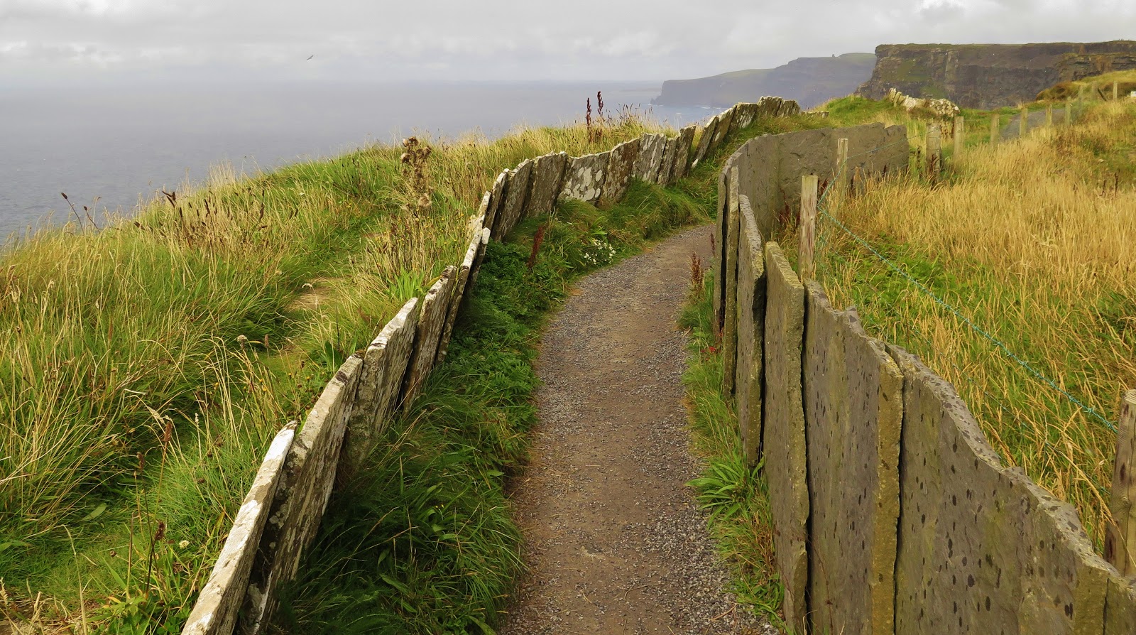
Pathway lined with slate slabs at Hag's Head, Cliffs of Moher, Ireland
Cliffs of Moher Coastal Walk


Detailed map of shuttle bus stops along the Cliffs of Moher hiking trail from Hag's Head to Doolin, County Clare, Ireland


A shuttle bus service operates March 1st through October 31st bringing hikers back and forth to their car or bus connection.  There are four access points to the Coastal Trail; Liscannor, Hags Head, The Cliffs of Moher Visitor Center and Doolin (which has five bus pick-up locations.) For shuttle-bus information and schedules see COASTAL WALK SHUTTLE BUS.  From Hag's Head to the Visitor Center it is approximately 5.6 kilometres and takes about 2 hours to walk and then from the Visitor Centre to Doolin is another 7.7 kilometres which takes about another 3-3.5 hours.  The total walk is about 5-5.5 hours depending on fitness levels and how many times you stop to take photos!  


Walk through farmers fields to the Hag's Head trailhead at the abandoned telegraph tower, Cliffs of Moher walk, Ireland
Walk Towards The Telegraph Tower


For our Cliffs of Moher experience, we parked at the Kilconnel parking lot for  €2.  The parking lot is located on private land off a farm road just past the town of Liscannor.  Heading north from Lisconnor on the R-478, turn towards the coast at the intersection of Saint Brigid's Well (worth the stop to check this Holy Site out) and then follow the signs for parking.   Once you pay the parking attendant who will direct you where to park, you walk uphill through farmers fields for about a kilometre or so to join the coastal hiking trail.   We recommend arriving early to guarantee a parking space is available. 

Please respect the private farm property and take care not to drop litter or feed the animals (no matter how cute they are!) 


Sitting on the edge of the Cliffs of Moher, County Clare, Ireland
Take EXTREME Caution Near The Edge


The hiking trail itself is quite level with only a few sets of stairs near the abandoned telegraph tower.  The path here is lined with large slabs of slate, and if you look closely at the stone, you can see fossilized worm tracks from when this rock was just mere sand on the ocean floor.  

The path does come very close to the edge of cliffs in several places.  There are no fences or safety railings on this part of the coastal cliffs trail.  The cliff's edge is often slippery, and the gusts of strong wind that can slam into the cliffs without warning are enough to bowl you over at times.  Even earlier this year in 2019, a student taking a selfie on the cliff's edge lost his footing, falling to his death.  The recommendation for children is that no child under the age of 10 walks the trail from Hag's Head to the visitor centre.  I think that as long as you are supervising your children carefully, hiking the coastal trail should not be a problem.


The Cliffs of Moher looking northward towards Doolin, Ireland


Petting some of the friendliest horses along the Cliffs of Moher coastal walk from Hag's Head to Doolin, Ireland
Making Friends Along The Hike

The weather can turn abruptly on Ireland's west coast; all the pictures in this blog post were taken within a few hours of each other.  You know what they say about the Irish climate: "If you don't like the weather; just wait five minutes!"  It's so true!  For this hike, I suggest dressing in layers with a good wind/waterproof jacket and sturdy walking shoes.  Bring along a water bottle and perhaps a snack, although the Visitor center is a good place to stop in for food.  You may also want to pack bug repellant because at certain times of year the gnats are terrible along the grassy cliffside!  Sunscreen and sunglasses are also a smart thing to bring.


The coastal walk from Hags Head to Doolin along The Cliffs of Moher, County Clare, IrelandThe walk from the Visitor Centre to Doolin is not as dramatic as the first half of the hike, yet still beautiful.  The path winds past the Centre and slopes gradually down towards the sea at Doolin.  Doolin is a great place to stop in for a pint or a dinner at a pub.  Doolin is also a great place for Irish Trad Music in the pubs.  You can also book a boat cruise to see the cliffs of Moher from a different perspective-the water.  A one hour cruise is €20 (discount for online booking), and two companies offer cruises three times per day weather permitting.  www.doolin2aranferries.com and www.obrienline.com  Doolin is also the place where you catch the ferry to the Aran Islands with the same boat companies. 


Enjoy your visit to the Cliffs of Moher even if the weather is wet; because you know how the old saying goes: 


"you can't have rainbows without the rain!"


Double rainbow on the Cliffs of Moher Walk from Hag's Head to Doolin, Ireland


Follow me on FACEBOOKINSTAGRAM  and  BLOGLOVIN'  for daily photos and updates! #slowtravel🐌 #dulgomall